Theodor Wirth Park
Length of ride:4 - 1/2
Difficulty:Easy to Moderate
Description of Ride:
Theodore Wirth Park
This trail is one that was built
by the Minneapolis Park Board and the Minneapolis Offroad Cycling
Advocates (MOCA). It is in two parts, one in a small section of
woods located at the corner of Olson Memorial Hwy, and Theodore
Wirth Pky. There is a map board located on the corner and the
trail starts right behind it. The mountain bike trail map is
located on one panel, the south facing one, and other information
and maps are located on the other panels. The trails are all one
way.
The first trail, that I think is
somewhat less then a mile, heads off to the west edge of the
park, and follows the boundary. I road this loop three times, and
every time there was a chipmunck that had his home in the middle
of the track. Every time I came through, he would be sitting in
the trail, and would dash into the hole in the middle of the
single track.
The track itself was narrow and
ran up and down along a slope. It was easy to ride, toward the
north end there was a couple of obstacles, in the form of some
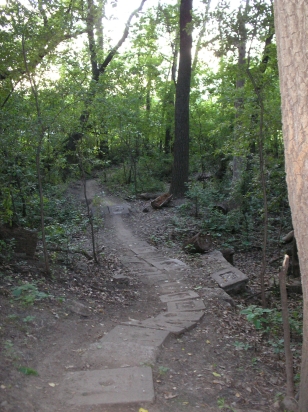
rocks and a couple of small logs. One section that had a row of
cement paver stones going down a slope. At the end of the track
there is a row of rocks that has to be bumped up and over to make
the trail end. Be sure and have enough momentum to lift your
front end when you hit them, and a single crank well get you
over. The return track runs along the ridge back to the trail
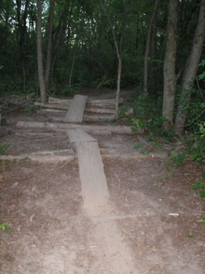
head. It has some more challenging obstacles along it. One
section where there are a bunch of logs laying perpendicular to
the trail with a couple of larger logs on top of them. The
formation makes a ramp up and down, then up and down again. I
went around it, because I didn't like the layout. The trail
beyond the logs has a few small rock obstacles and a couple of
swooping banked turns. Lots of fun. If you come to the log
obstacle and like me, find it a little too much, then be sure to
walk your bike over it and ride the rest of the trail instead of
taking the alternate route that takes you out to the paved
path.
The second trail is further on
down the road. If instead of making the return loop along the
ridge, you go out onto the paved trail and ride north a ways,
there is a second trail. The trail head is not real obvious. To
find the path, ride around the gate on the roadway that parallels
the golf coarse. The golf coarse is not obvious ether. Ride down
the road for quarter mile or so, and there well be a trail sign
and map on the south side. The trail is about three miles in
length and serpentines through the woods. It makes some small
climbs and is a fairly easy ride. Some small obstacles and a few
narrow places, but all in all the ride is easy to intermediate.
Watch out for other riders, because the regular users are very
tuned into the trail and hit it hard. There is supposed to be an
advanced loop off this trail, but I missed it.
The trails here are closed if the ground
is wet. The soil won't hold up to the heavy use by the
public when it is wet. When I road it, it was dry and the sign on
the map said trail open.


