Phils World Cortez Colorado
Length of: Bike Ride 20 Miles
Difficulty: Moderate
Description of Ride:
Phil's World Cortez Colorad
This is a paid trail system. The cost was $3.00 per day on a daily uses bases. I felt the charge was expectable. The trail system was in excellent shape. My only complaint would be in the signage.
The trail is located about 4 miles east of Cortez, across from the fair grounds. It is located next to the Four Corners Gun Club shooting range
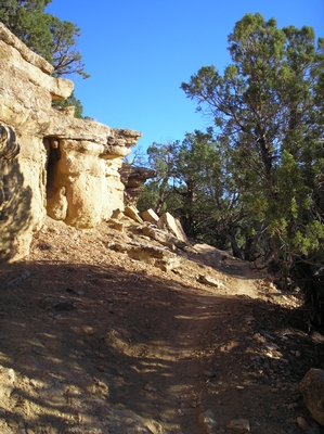
The trail starts at an opening in the gate. There is a sign board with a collection station there. Only one trail leading away and it ascends at a very acceptable grade. The trail meanders through the juniper and sage, with a couple of quick wash crossings. One is a slight challenge because as the trail cross through the bottom of a shallow wash, I had to negotiate a large bolder on the opposite side. I kept the bike in a lower mid range, if the gearing is too low, it is hard to get the back wheel over the bolder. The trail is easy to ride in the mid gear range. Since I am from the west coast the altitude did give me a cause to stop and catch my breath a couple of times, but the second time I rode it I was prepared for the short hard climbs and selected my gears appropriately.
After about a mile, the trail comes to the top of a ridge that is also a juncture. The return trail crosses here. The trail system is set up to ride in one direction. If you were inclined, you could ride down the return trail, and end up with a ride of about two miles
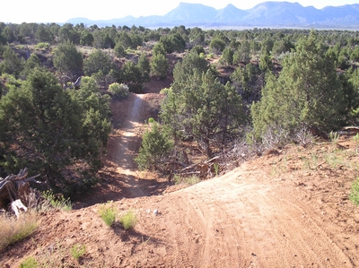
This section of the trail is called Coco's. It is down hill for the next 3/4 mile or so. Great swooping run, the single track rolls through the juniper, twisting and turning, dropping through small washes and back up the other side. Descending through the cover till it reaches an open area, covered in sage. As the trail breaks into the open, it crosses a small ravine. A drop of about ten feet, speed is essential here to gain the high ground on the other side. As soon as the other side is gained, the trail starts to climb again.
The climb at first is very radical, a low gear combination, and weight the front of the bike to make the first thirty to forty feet. Then the trail starts angling off parallel to the ridge line. The trail climbs in small sections until it is following along about fifteen to twenty feet below the mesa top. Using the right gear combinations, it is a moderate ride for the next half mile. At about the two mile point, the trail rounds the mesa
This is another juncture. The trail continues on under the name of Lemon Head. The return side of Lemon Head is about 50 feet away across the saddle formed between this mesa and another one to the north. There is an old road heading in that direction, with a large dirt pile, put there to stop vehicles. I could have opted to ride over there and pick up the trail right after the Bobs Loop section. But I didn'
The Lemon Head section starts much like the Coco's section did. It swoops down through the juniper, twisting and turning until it comes back around and climbs up onto the mesa. The jump up onto the mesa, is stepped like, climbing up small rock ledges, that are spaced eight to ten feet apart. It follows along the edge running about ten feet back. There is one section along the east side where it gets a little close, and that section is indicated on the map by a skull and cross bones
The trail continues off through juniper trees with views of the surrounding landscape. The ride becomes much easer along the next couple of miles, and I found my self riding fairly fast. The Lemon Head trail loops around and regains the saddle between the mesas. This is where the Lemon Head trail section started. I missed this cut off, and ended up riding the Bob's loop. A one and a half mile loop that runs along the top and western edge of yet another mesa, then ends up at the same saddle. From here the trail runs somewhat east through junipers for about a quarter mile. Then the Abajo section turns off to the north
The Abajo section quickly climbs up to the top of the Northern mesa. There is one section, about twenty feet long, that is very dangerous. The map again indicates the section with a skull and cross bones. The trail runs out onto a rock, and around a tree. No room for error here. With in a few feet, there is a great overlook from the top of a rock outcropping. The trail turns north and runs along the top of the mesa. The area has sparse vegetation and the ride is on and off the rock outcroppings along this section. After about a half mile, there is an intersection with the Stinky Spring Loop. I opted not to ride the loop. Instead I turned back south on the Rib Cage section. At first the trail was much the same as it had been, sparse vegetation, running along a well packed dirt trail.
After a quarter mile or so, the trail disappeared over a sharp edge. I slammed on my breaks, skidding to a stop, just before the drop. The trail drops a good fifteen to twenty feet. So vertical that I don't believe a person could walk or climb up it. I turned around and moved back up the trail. Jumped on the saddle and headed over the edge. Great whop de-do. The drop gave me enough momentum that I whipped up the other side. There are probably eight to twelve of these. One after the other, with a couple of sharp turns, sending the trail east, then south, then back west and south again. This section needs to have a loop around, so that you can ride it again and again. Great fun. Shortly the trail rejoins the main trail and the ride starts descending.
There are more of these whop de-dos, but not as big. A couple of small jumps in the trail, flagged when I came through, which is a good thing. I would not want to hit these without knowing they were there. My speed was pretty fast as I approached them. If they had not been marked, I probably would have wiped out. They aren't very big, but it is the unknown. The trail continues on across the low brush area between the mesas, it then crosses a small wash. It starts climbing here and finishes at the first saddle or the Coco-Phil's trail intersection. The last bit of trail runs down hill and has nothing that stands out. It just runs down the hill, crosses an old jeep road, then meanders along a double track to the dirt road that it starts on. It ends about half a mile from where it started. This last section would be nice to have it reworked. It is always nice to end on a good run