Makawao
Length of: Bike Ride 10 Miles
Difficulty: Easy
Description of Ride:
Kahakapao trail in Makwao, cowboy country. The trail is the only real developed single track on the island that I have been able to find. To get there drive to Makawao and take Makawao road or highway 365 out of town toward the south. About 2 blocks out of town turn up hill onto Piiholo Rd and drive for about a mile and a half. Turn on to Waiahiwi Rd and follow it to the second right, Kahakapao Rd and follow that to the parking area. If the gate at the end of the road is open there is a parking area a mile beyond it, if not park along side the road at the gate. Do not block the gate
I road from the gate and I don't know if our car would have made the water bar in the road on the other side of the gate, there were lots of black marks across that thing. From the gate the road is very steep going down, just to reach the bottom and ascend a very steep grade on the other side. On the right about 3/4 of a mile up the road I found a trail to the trail that took me to the trail head. This little connector trail was the most technical part of the ride that I did that day. Still very ride-able, lots of switchbacks and ended at a gate
Through the gate was a double track that crossed a couple of small ravines then turned up hill and climbed straight up. This was very smooth and easy to ride. I did notice what looked like a single track off this trail but it was not marked. Maybe a half mile along this fire road there is a trail head with a sign Kahakapao Loop Trail. There were two signs that pointed left and right they read 'East Loop' and 'West Loop'. I decided to ride the 'East Loop'.
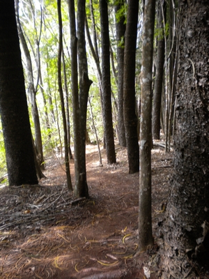
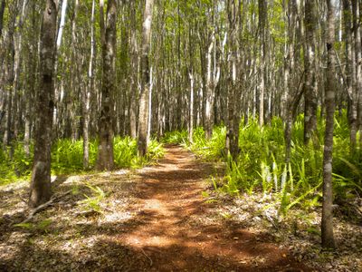
The trail was laid out at an excellent grade, I was able to ride almost the whole trail in the lowest ring gear and the second and third sprockets. Shortly after the start of the trail there was another sign that pointed off to what I well assume was the East since I was on the 'East Loop' that indicated a trail called 'Fong Ridge'. The trail switched back up and up for the next two and three quarter miles through mostly the same deep forest setting. The forest was open under the trees, very little underbrush. The tree bark reminded me somewhat of aspen. The leaves that covered the ground were long and slender about six inches in length and an inch in width. There was one spot where the trail crossed a small ravine and a couple of places where the vegetation changed for a very short distance to some type of pine or fir tree. The surrounding landscape varied from wide open and almost no undergrowth to areas that were thick with tall grass. There were a couple of short sections along the trail where the canopy opened up a little and the understory became thick with small delicate looking ferns. At the top of the trail were three signs, 'East Loop', 'West Loop', and 'Fong Ridge'. So east loop is not a loop but the east side of a single loop.
Just as I reached the trail intersection some hikers came by. I asked them about the west loop trail and one replied that it had two choices coming up the main trail switched back with a comfortable grade and there was what he termed a fire road that ran more directly up and down the hill. I decided to return back down the trail I had just come up.
The descent was fast but very controllable and not technical at all. There were lots of switch backs, but only one was banked so the flow could have been better. It was still a lot of fun.