
Toutle Trail No#238
Difficulty: Easy to Moderate
Suggested Skill Level: Beginner to Intermediate
Trailhead longitude and latitude: 46 08 37N, 122 14 05W
Google Trail Head Location
 Google Directions From Portland
Description of Ride:
Toutle Trail 238The trailhead is at red rock pass on forest road 8100. The trail starts into a lava bead with a short ascent through a single switchback. It moves northward across the lava. The trail here was still under development when I road it. There are areas in the lava where large lava rocks have been piled into the crevices to make the trail more walk able. Some of the lava rocks have fractured like obsidian does and are very sharp. On the way up the trail, I walked my bike across these areas, but on the return trip I decided to ride over the boulders. Not a good idea. I punctured my tire and pierced the tube in two places. Lucky it was just about a 1/4 mile to the end of the trail.
The lava field is about a quarter mile across then the trail enters a meadow. The trail along here is all ash (sand) and in the summer harder to ride. This day had the trail fairly compacted from the rain on the previous day. I was wearing rain gear because the bear grass, small trees, and brush is very wet. The trail has a number of places where large smooth lava boulders form steps with rounded faces ranging from 6 to 8 inches in height. Although they look formidable they are easy to ride over. Another 1/4 mile and the trail enters into an open conifer forest.
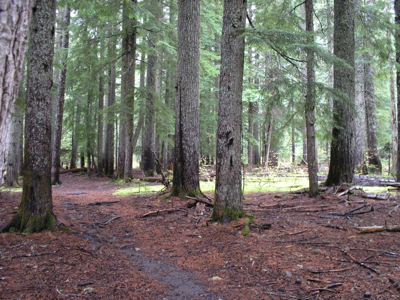
The ground under the trees is red with decaying pine needles. Open areas amongst the timber are bright green with moss. There are small roots and lose rock and rubble along the trail as it steadily ascends. The landscape switches back and forth here between the smooth needle covered ash and lava rock outcroppings. The trail showing the signs of the heavy rains yesterday, having the look of a small stream down the center. The ride is not hard, just a little technical. I am ridding in the first ring gear on the front sprocket, and switching between the lowest three gears on the rear sprocket. The front wheel is twisting and turning as I push up over lots of small lava outcroppings. These formations are not as smooth as the ones in the meadow.
I enjoy this part of the ride a lot, the ability to negotiate the small outcroppings and the roots crossing the trail. This part of the trail is mostly uphill at a moderate grade. A younger experienced rider would probably ride this in a standing position, pressing harder over the outcroppings. I do this now and then, but don't have the stamina to keep it up. It is the kind of ride though where there is enough level or near level areas that I can catch my breath and let my heart rate come down without having to stop.
At a 1-1/4 miles Butte Camp trail No#238A diverges from this one. The sign says the camp is another 1-1/4 miles, and Loowit trail is another 1-1/2 miles beyond that. The Toutle trail levels out a lot more here. It maintains a moderate grade both up and down as it traverses each ridge. The outcropping presents more challenges in the form of half burred rocks, exposed roots crossing the trail and more of the small lava outcroppings. Another 1/2 mile and the trail enters a brief section of tall old growth timber.
The trees are very tall here, there is a creek crossing with no bridge, and the forest floor in one section along here looks to be a hundred feet below the trail. There is an obvious animal trail crossing at the creek below some giant boulders. A full size tree looks as though it is growing out of one of the moss-covered boulders. This is an exceptional area along the trail. The trail heads around a large ridge and up a valley to exit the deep forest.
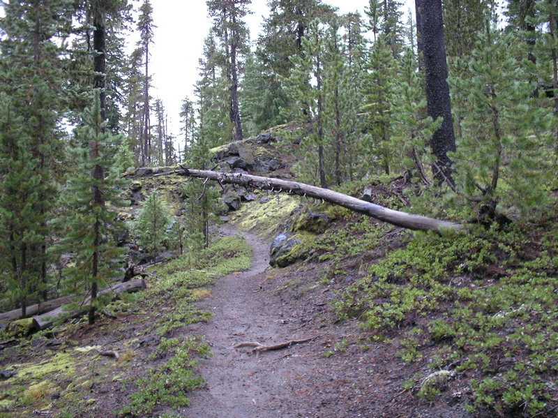
After a short climb out of the valley, the trail turns sharply and starts breaking into an area of smaller trees, it levels out and starts to descend a little. The terrain is becoming rocky and the trees now look like a tree farm. There are none over 15 feet in height, packed tightly together, the branches thick and heavy with shimmering water droplets. The visibility here this area limited in any direction except down the trail. A couple of tenths of a mile and the trail crosses a creek bed.
The creek is dry now, and every time I have been here it has been dry. The trail continues on the opposing bank about 50 feet down the creek. The whole area is rock and ash so you have to carry your bike up and down the creek banks between tail sections. The creek bed itself is about 10 feet deep. The next half-mile of trail descends slightly.
The terrain is very rocky and hard packed ash. The trees here have been stunted by the aired rocky soil. They are spindly looking fir trees like you would normally see in a lava field. The largest is only 10 to 12 inches in diameter. The ride here is not bad considering the amount of rock and small boulders. I am able to skirt around most of the rocks, with only a few areas where I am challenged by riding across short patches of rubble. There are a couple of downed trees across the path where I have to stop and carry my bike. The trail is intersected by another trail just 1/4 mile for the end (or beginning).
The Blue Horse trail No#237 cross the Toutle trail. To the south is road 8100, to the north is Huckleberry Saddle. I have both ridden and hiked the trail to the south. Don't bother. It is like ridding down a creek bed. All lose rock and ash. It is a horse trail after all, and horses tear a trail up worse then anything I have ever seen. The few areas that are not like a creek bed are so deeply rutted from horse travel that they are not worth ridding.
If you were insistent on ridding a loop, continue on to the trailhead, and ride back by the road. That would make it about an 8-9 mile loop. I don't find anything especially attractive about riding a loop, for me it is the ride. Out and back is perfectly acceptable. From here the total ride, out and back, is 6 miles. The trip back is much faster since most of the ride to this point was up hill. A moderate uphill grade back to the dry creek bed, then almost the entire return trip is down hill.
