Ride Report Archive PNW 2013
The Gran Fondo of Growlers Gulch.
The Growlers Gulch 5k. How Hard Can It Be!
Every year for almost a decade, Growlers Gulch Racing has put on the 5k event. At its core is a developmental tool to get everyone in shape for the summers riding.
It is not a race but it is still timed. The timing is for the individual, a performance measurement.
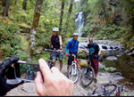
The route was laid out to start and end at Jeeps house.
A stiff climb up a half mile of pavement to pick up a gravel road for another stiff climb up and into the woods.
We follow gravel for another half mile before we hit single track.
This section of trail would be ridden once in and out.
This first single track section is called
Big Wow and would also only be ridden once. A steep line that descends over 400 feet in about a half a mile.
This bit of single track has seen lots of carnage over the years, the line drops off the road side trail and presents a short ride across a half log that stretches across a big dip.
A couple of turns and another big dip presents the biggest challenge on this trail. A steep hillside where the trail tracks down between two trees.
The key is, weight back over the rear tire, light pressure on your breaks until you start to skid, then modulate gently, trying to stay upright as you skid down between the trees and the line breaks to the left.
There is an out at the top, an alternate line. It dumps you on the Ridge trail which you can ride down twenty feet and turn to descend another steep and drop back onto the Big Wow trail. This option, although there are no trees to dodge is no gimme. It too is an out of control skid with a sharp left at the bottom.
The Big Wow is fast with lots of drops and short steeps that will keep you on the back of the bike for most of the descent.
The Big Wow junctions with a connector trail that is used on the return, the connector takes you over to the Ridge trail for the final ascent on the return trip.
The route follows a secondary gravel road for another half mile or so to reach the bottom of the main section of the route. Everything from this point will be ridden twice, two laps.
This was my second 5k, last year I teamed up with a friend, Barry DeSemple and we rode the first lap together. Then I felt like I wanted to put a little more into it and we split up for the second lap.
Last year I had taken the strategy offered by some friends who had participated in the event many times.
The highest point of the ride is on a trail called Legacy. The Legacy trail runs through a clear cut that has been replanted, the trees ranging in height from a few feet to ten-twelve feet.
The Legacy line provides lots of exposure to the elements and on a wet day can soak you through from all the contact with the small trees and just a hint of wind can make it a chilling experience.
A couple of years back the event was held on a wet breezy day and a couple of friends decided to take the Legacy line twice while they were up there.
Their strategy a double loop and it was done. No more exposure to the elements. The lower trails under timber for the most part with less wind exposure.
On my first 5k, the weather was great. But when I reached the Legacy trail I decided to just go ahead and make a double. The strategy worked well for me. The faster riders who had started later, were just starting to catch up to me. I looped back around as they headed down, putting me behind them.
I had been thinking about last years strategy and decided to expand on it, breaking the main climb into four sections.
The first trail to climb is a single track called Plan B. The Plan B trail runs at a moderate grade through the lower forest. It makes a short climb then turns to roll across the hillside. The line swooping through large dips and providing a great ascent in short spurts. The track rounding a couple of quick banked switchback with short steep climbs before relenting at a junction with The Secret Garden trail.
The route merges with the Secret Garden trail for a few feet before providing an out to a spur road instead of climbing a line that is designed for descending.
Another connector trail has been put in, at the end of the spur road. It runs along the hillside and puts you on the Bitter Bitch, a trail designed for climbing.
The route breaks into Bitter Bitch in the middle of a big section of switchbacks. All of them very ride-able, a section I ride in my small ring gear and second or third sprocket gear.
I ground out the climb to the junction of A-Bomb. This will be my first repeat section.
My plan is to bomb the bomb and repeat the climb I just did.
A-Bomb is just over a year old and I think has become a big favorite with me. The name is very accurate.
The trail starts with a quick swooping track through the woods to slam through a banked corner and put you on top of the first of many steep sections. The steep is on a wide plane and has started to become rutted with breaking bumps.
The trail swoops through a couple more switchbacks, crossing a wet area then turns to descend a steep pitch through the woods with lots of root hopping and a couple of swales to roll before dropping through a gully.
The bottom of the gully contains a small stream and when the trail was built there was a simple bridge built out of short rounds laid sideways across a support. I would find the crossing destroyed by the end of the day.
More steep descending that had me back over the rear wheel, arms outstretched but loose enough to absorb what my front shock could not.
There is another big gully before the trail traverses through the woods to present a big log ride, with an optional (my route) ride around. My friend Bob Horness, always takes the logs.
The approach is a quick step up onto a large three foot wide log that has been laying on the hillside for decades. At the end of the log is another small connector log, cut and shaped into a flat transition down onto a second smaller log that dumps you off the end and back onto the trail.
The Bomb keeps serving it up. It is an exciting fast descent down the hill that levels toward the end and presents lots of rolling pumping track until it reaches the secondary gravel road. The exit is just a hundred feet from the climb I had just completed.
I repeated the climb up plan B and the top end of Bitter Bitch to exit onto gravel.
I wanted to be sure that I hit all the trails twice so I knew that I would need to hit the second half of the middle KMA trail here so that I would not have to do it twice on the final descent.
The KMA trail is broken up into three sections and the middle section, which itself is broken up into two pieces, is the only part of the KMA trail in the route this year. A couple of years ago all three trails sections were included.
A quick crossover on gravel brought me around to the trail entrance, the trail presents a fast line on a mellow grade through the forest from one spur road to another. There are a couple of transitions and roots to bounce over but for the most part, just a fast smooth line, right up until it is not.
Just before the end of the trail there is a steep up, a good ten to twelve feet of steep bare, hard packed dirt. It catches everyone on their first visit. The approach is short and on a corner so you are on it before you know it. Steep enough that if it is wet, you will slip and fall on the greasy slope when you try to dismount.
It is hard to get enough speed on the short approach and having the right gear is the key to success. Too low a gear and you will never be able to gain the speed, too high a gear and you won't be able to power up and over the vertical.
I shifted into the small ring gear and my forth sprocket as I leaned into the turn. Then cranking to my maximum I hit the steep slope and stood up to apply all my power to the last couple of pedal stokes as the steep slope quickly sucked the energy out of my effort. My momentum almost completely dissipated and my bike nearly stalled, I broke over the top and eased back into the saddle as the line flatted out.
The trail splits just before the gravel, the right line took me down to the road and back up to the exit/entrance of Bitter Bitch.
The route here turns into gravel. A quarter mile of flat secondary gravel road to a junction with the primary gravel road in this forest.
Our route was to turn uphill and climb for another half mile or so until we reached the next single track, Little Sister.
I ground my way up the gravel, well packed from all the logging trucks that have been using it this year. I was up here last week and had seen or heard a half a dozen trucks as I climbed the 5k route.
The first section of road is steep, climbing up through a couple of corners where the KMA trail crosses and descends to merge with Jekyll and Hyde. I'll see that section later.
The next section of single track breaks off to the left just after crossing the creek, the Little Sister trail.
The entrance to Little Sister is a little rough and rumble, a good spot for a low mid range gear combination.
A quick pump and roll, the line drops then quickly ascends a short climb to break into a nice moderate grade with lots of rolling terrain.
The trail crosses an old spur road, the entrance here is a little tricky with a sharp right turn on a rolling corner.
There is more moderate climbing with lots of rolling features that are super fun and fast on the descent. The trail running parallel to the road, then taking a left to climb at a steeper grade through a couple of switchbacks.
Little Sister ends at the Rail Road grade.
Our route following the grade for a few hundred feet to a spur road that heads uphill, just before the Rail Road grade ends at the main gravel road.
The spur road has both the start and finish of the ABC trails, the finish at the start of the spur, the start at the end of the spur.
The entrance into the ABC trail system is another quick up, not a huge steep, maybe six feet of a sharp steep grade, a mid range gear with a fast approach will have you up and over the steep in a few peddle strokes.
The line along here is a fast pump and glide. A very nice bit of trail with one small log drop and a couple of stump and log over options, none of which I would attempt this day.
The trail reaches an intersection after five minutes of riding.
This intersection representing a location where the ABC trails are both coming and going. Making a right and keeping right the trail transitions from single track into a skidder road to intersect with a secondary gravel road.
Up the gravel road just, twenty feet or so is the next section of single track, the Creation trail.
Yet another steep entrance, the up is broken into two gigantic steeps, again a mid range gear combination with lots of power will get you up the hill and start you on the difficult climb up the Creation trail.
The Creation trail was put in as a down hill line. Last year it was used in the 5k and some of the more difficult sections were massaged and worked until they were do-able.
This is a difficult climb, probably the most difficult on the 5k route.
After the trail entrance the line climbs up a moderate grade that had me in my small ring gear and the second or third sprocket. A good crank it out climb for the first third of the trail, then the challenge begins.
The line becomes a little steeper, negotiating a route that includes a pinch between a huge stump and tree where the pedal placement and quick ratcheting action may be require to clear it. Follow this with a couple of big dips, lined on the exit with roots and a weaving line that skirts large stumps and root wads.
If I clear this I feel pretty good, but I am also not disappointed if I find myself off my bike to push past some of the features.
Not half way through the climb, the trail turns to cross a creek on a large log, a place I have never pushed myself to clear. The turn is a hard turn going up or down. The exit off the log is into a steep climb and a set of switchbacks.
The fun continues through steep climbing, more deep wells and root steps to another creek crossing on a short piece of half log.
The creek crossing puts you on the last steep climb, where at the top it turns and bounce over a log, one that I pedal strike nine times out of ten.
Creation continues at a moderate climb as the trail twists and turns up the hill to the main gravel road.
There is a short section of Creation on the other side but no one ever rides up that, good moderately technical downhill stuff though.
Our route takes us up the gravel a few hundred feet to a spur road with a tank trap at its entrance.
I have seen one person ride the tank trap, my friend Bob tries every time and come close, I just get off and walk through it.
The spur road is lined with lots of small alder, green and soothing, the trail is a low grade grind to the end of the spur road and the start of the next section, the Legacy trail.
A few years back, on a cold wet day in the fall, a crew of 75 mountain bikers roughed in a new line. The trail circles a mountain top that had been logged maybe ten years earlier. It would be another twenty years before the timber company would be back so it would be their legacy to the next generation of mountain bikers.
The trail, like so many, starts with a steep up. A six foot jump up and the trail turns to run through a short section of small deciduous trees before breaking into the open clear cut.
The line meanders uphill for a ways, a moderate climb that finds me in my third or forth sprocket and small ring gear. The trail weaving back and forth until it opens up to a view north, where on a clear day you can see the Olympic mountains.
A nice descent across the hillside to another short climb, followed by another descent through a couple of switchbacks.
The trail turns to circumvent the mountain with lots of short steep sections and semi-technical root overs.
Half way around the mountain there is a sharp switchback and stiff climb. That extends half way up the mountain before the trail again returns to a meandering climb finishing at the top.
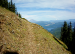
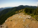
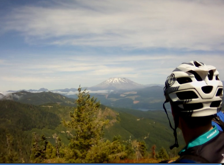
The view from the top of Legacy is outstanding. All the major volcanic peaks from Rainier to Hood are visible, with the Goat Rocks stretching across the horizon to the north from Mt Adams.
After reaching the top of Legacy, there is a fast ripping downhill back to the spur road. The line drops through a couple of natural banks to flash across the hillside, hammering lots of swells to a point where the trail drops straight down the face of the hill. A steep drop that is rutted with breaking bumps.
The line taking a couple of turns to run across the face of the hill to a big drop and roll across a large mound. The trail then turns to flow through the deciduous trees and rumble across a couple of logs to exit back onto the skidder road.
This would be the place where I would loop around to take my second lap on Legacy.
As I exited Legacy for the second time, I rolled across the skidder road to bounce through a rock garden and into the entrance of WTF.
The WTF trail runs through a stand of trees that are a few years older than the ones on Legacy, the trees being ten to twelve feet tall.
The line weaves its way through the small trees providing lots of pump action until it breaks to start a descent.
The grade moderate at first, then a turn to skid down a narrow line to an equally narrow bench at the bottom.
The trail drops and swoops across another bench, then repeats this a few times before streaking down a rough and rumble root crossed line to end on a secondary gravel road.
A hundred feet up the gravel and there is a trail that drops off to the left; Vortex.
The Vortex trail is a great trail for both climbing and descending. The flow of the trail is such that the climb can be done in a low to mid range gear combination and the descent can be done in a screaming fast blast through the trees.
The line drops off the edge of the gravel and into the forest, a conifer forest with the timber being in the fifteen year old range, small trees but large enough to form a solid canopy overhead.
The trail forms a mildly rolling line across the hillside, turning to run down hill and then back again across the hillside several times in a two minute blast to the next break in the line.
The trail empties out onto an unused spur road.
With a few pedal strokes up the road the next section of Vortex appears on the right, a dark arched opening created by the limbs of the small fir trees.
The trail drops through an opening in the trees to scream right into a big banked corner that is followed by a large roller that provides the opportunity to catch air.
I was riding with some very strong and experienced riders here and watched two of them catch air and tail whip into the banked corner that follows. Where I just railed the first corner, threw my weight back and rolled the big roller to dive into the next bank with my outside pedal weighted to rail again through the second corner.
The line runs fast through the second section of Vortex, with a couple three more large berms and a kicker to hit while blasting down the trail.
Vortex dumps you onto the gravel at an intersection with the main arterial running up the hill, the 9300 road.
This is where I would make my next loop, to roll down the gravel a few yards and pick up the rail road grade, and turn uphill and back into the ABC trails.
In years past we had aid stations on the course, manned by friends and family. But we had problems with security, since we were riding on private timber land. So this year the course was self supported, meaning you had to provide water and aid for your self by hiding a cache somewhere along the route. I was very fortunate that a good friend, Vaughn Martin, was going to hide some water for himself and offered to stash a cache of water for me and another friend Bob Horness.
I entered the woods to find my cache located in the crotch of an old stump.
As I was refilling my hydration bladder, Bob Horness came blasting up the trail. He looked like he was pounding out the miles and the climb with his usual abandon. He had a big grin on his face as he approached. We exchanged a few words and I took off to take on Creation, WTF, and Vortex for my second loop.
When I reached the bottom of Vortex, I turned my bike onto the Jekyll line. The trail staring just a few feet down the main road. It meanders through the woods at first on a mostly level line, making its way over to the edge of a big drop where it turns to skirt the steep hillside.
The line provides a couple of challenges, opportunities for pain and suffering. There is a large old log that sits at a slight angle to the line.
On a downhill run it is an easy roll but when climbing this short section, I have missed clearing it and found myself dancing on one leg toward the edge.
I had to apply the ten foot rule. I walked the next ten to twenty feet up over the log and followed the narrow line back up to where I felt comfortable remounting my bike.
Jekyll takes a turn down hill and continues at a fast blasting pace. The line is very well established and provides for plenty of speed.
The trail is broken up into a couple of sections, the top being fast with features like root drops, log rolls and short quick skidding steeps. The second half provides some steeper sections and a couple of stream crossings.
The Jekyll trail merges with middle KMA after a very steep descent, followed by an equally steep ascent.
The upper middle KMA blast down a line that swoops through the woods for more quick paced turns on well developed corners.
There is a short climb back up through the timber toward the bottom of the first section of middle KMA to be followed by one last hammer section. A very steep descent into two well developed berms that provide plenty of height to carry almost all the speed from the descent.
Rolling up to the top of the steep hill. I push my weight back over the tire and easy over the top of the steep. A large berm waiting at the bottom.
The sound of my brake rotors rumbling softly as I quickly pick up speed. Pushing my bike further out in front of me, I let go of the breaks. Free-falling down the hillside, my front wheel hits the edge of the berm as I push down on the handle bar with my left hand while shifting my weight over and onto my outside pedal. The inertial phenomenon takes over and I whip through the turn to launch out and hurdle toward the second berm. Quickly swinging the bike under me and push down on the right side of the handle bar, shifting my weight to the outside pedal again to blast through the second berm. That launching me on to the trail, throwing my weight back I drop through a big ditch and hit the gravel to skid to a stop, ending the blast down the first middle KMA section.
Another climb up the road and onto the Little Sister trail, back out to the gravel on the Rail Road grade and a second run down Jekyll, this time to finish by hitting the lower middle KMA and ending my second lap of this section.
A short ride up the gravel road to the Bitter Bitch trail and back down to finish my final descent on A-Bomb.
The end of A-Bomb puts me back on the lower secondary gravel road that I rode in on this morning.
I catch up to a couple more riders just as we start into the exit of Big Wow.
We head back up the same way we came down except we cross over a ridge at the bottom of Big Wow and finish the climb out on the Ridge trail.
The climb out on the Ridge trail is broken into a low gear grind with a couple of semi-flat areas on the ridge. Normally I would gear up when the grade broke but today I would just keep my gearing low and spin my way through here.
The Ridge trail empties out on the main gravel road and a moderate climb to head back out the way I came in this morning.
My friend Bob did the 5k in 4 hours and 33 minutes. I finished a few minutes behind him at 4 hours and 46 minutes. There was no gas left in my tank.
It was a long ride and I don't think I will be looking to better my time in the future, maybe just riding it is enough.
GITs (Guide In Training) ride the Heckletooth Trail.
I was approached, while at Barbie Camp this spring, and asked if I would be interested in being a guide for Mountain Bike Oregon.
There is no monitory reward for guiding, just a buff that says "Guide" and a lot of great single track with the opportunity to make lots of new friends.
Being a guide also brings with it lots of extras like free beer (and/or wine) and food for three days.
After I signed up, I received an e-mail that instructed me to be in Oakridge Oregon for the mandatory GIT training day. We would be riding one of the more technical
trails, Heckletooth, and listen to an orientation (while sipping on a cold brew and eating burgers)
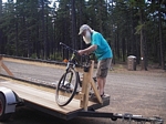
We met at the "Barn" just before nine and loaded all of our bikes into a U-haul before piling on a school bus.
There were 42 of us and as we would learn later that was the maximum occupancy of the school bus. During MBO each bus would have 35 clients and 7 guides.
I don't remember much about the ride out, there were so many new faces and conversation that I didn't pay much attention.
After we reached our destination and after some trail head orientation, we started turning cranks to ride a little over two miles up a mild to moderate incline on gravel, a
double track.
It was a big group gathered at the upper trail head, all of us waiting on our bikes for more instruction and eager to take on the trail. Rated five out of five for technical and
three out of five for grunt factor.
With our radios all tuned to the same channel, the ride captain gave us a few more instructions before the riders started dropping off the side of the road to descend into
the woods.
I swept wide on the gravel and rolled off the edge, through some brush and down a moderately steep hillside. The line quickly turned and I skidded to a stop behind
another rider who was waiting and watching as riders in front of him make the choice to ride down the very steep incline or to walk their bike down.
I watched as the guys in front of me all walked their bikes, it was steep but the real challenge was that the hillside was loose duff and rock.
I rolled across the slope and shifted my weight back as I turn into the descent. Slowing to a crawl at the top of the steep, my riding shorts were dragging on the back
wheel.
My breaks rumbled as I concentrated on staying upright and not skidding. Working both the front and rear brakes, lighter pressure on the front until I felt the back wheel
start to slide, then just a little more pressure on the front as I eased up on the back. The descent a series of little skids in the loose material as the bottom quickly
approached and I struggled to stay on the line.
My front wheel drifted just a bit off the line as I turned to follow the traversing trail across the steep hillside.
The trail much firmer and solidly packed in, not like the first part that resembled something my friends and I might have just built.
The trail runs through the forest across a moderate grade for a short stretch. The line rolling up and down with some short quick climb and run sections.
The side slope turns steep and the trail becomes narrow. The timber anchored to the hillside forming small platforms of earth with the trail rolling over one tree platform
to swoop down and across in a narrow arch to the next tree.
The trail is interrupted with a rocky outcrop, the group clustered up as each person worked their way over the rocky outcropping.
The trail took a couple of sharp switchbacks down through the rocky reach. It is an advanced line of rocky steps that led into two very sharp corners with penalties for a
mistake. I applied the ten foot rule and walked the switchbacks.
The trail descends at a fast rate down across the face of the ridge to a series of four switchbacks. I dabbed my way around most, the second pulling me off my bike to flip
it around and remount.
The switchbacks are followed, just a few feet down the trail, with some big rock drops. I might have taken a shot if I had just rolled into them but with the group stopping
to walk them I followed suite. The first couple of drops are the most technical, but once your off your bike...
The path provides little resistance from here on, a fast line that blasts across the face of the hill.
The tread is smooth forest floor with large roots to roll when passing over the back side of the timber.
The trail is not a real ripper but the natural features and angle of descent provide for a very quick pace. It is a narrow strip of trail running across the steep hillside forcing
my focus with an eye out for rocks and debris that could become a pedal strike.
About ten minutes later I could see a road below through the forest, the trail taking a steeper course as it dumps you out onto gravel. The same spot we had disembarked the bus
this morning.
After a regroup with more instruction we return to the trail.
The trail head; a break in the undergrowth with a well traveled entrance.
The trail drops down a mild slope, the line winding back and forth through the moderately thick understory.
All too soon the trail flattens out and presents some mild technical challenges in the form of root wads. The trail crossing these tendrils that form knotted webs running
across the forest floor.
The edge of the valley is defined by a small creek where the trail crosses on a plank bridge to start climbing.
A good place to have your gears in a low-mid range to push over the clusters of roots at the start of the climb.
I had heard about a gut buster climb toward the end of the ride, and as we cranked our way up through the timber I kept thinking this couldn't be it. The climb, for
me was mostly middle ring gear and second gear on the cluster.
It was a grinding climb but did have a good single track nature, it was not steady. There were plenty of short breaks where I could ease off the cranks and take a couple of
deep breaths before leaning into the next section.
A couple of minutes of grinding through moderately steep sections of the climb and the trail breaks to a quick run through the forest for a few seconds, a short break to
catch your breath and ease up a little.
Then the line turns again to present another earnest climb. A section that is just a little steeper and had me thinking I better shift down as soon as I can get enough of a
break to release the tension on my chain and drop to the small ring gear.
Standing and powering my way upward, the climb did not relent and I could feel myself starting to fade.
My heart pounded in my ears as I gasped for air.
Just as I was about to pull to the side and step off, like many others that I had just passed, the ascent broke. Within a dozen pedal stokes I was blasting through the forest
as the line headed down slope.
The track weaved and wandered across the slope, running fast through the tall second growth for several minutes.
Again, the trail started uphill. A moderate grade climb toward the far side of a wide ridge.
The trail along here was a climb and descend run, perfect for mid range gear riding.
This was indeed the "Gut Buster". The trail entered the edge of a burn, a bump up and over a root between two closely spaced trees and all of a sudden my
gearing was way to high.
Pulled from my bike, I started to push it up the hill like the riders ahead of me.
After a few feet, I stopped. Lifting my bike I spun the pedals and worked the shifters to gain my lowest gear.
I remounted and leaned into the steep grind.
I was unable to clear the climb. There were too many other riders and toward the top there are a couple of large root ups that are just too much.
We gained the top of the ridge. A spectacular view and a great place to take a break before the next challenge.
As I looked down into the valley I could see two large birds, wings outstretched, drifting on the air currents, slowly working their way up the steep hillside.
The group took to the trail that zigzagged across the face of the rocky ridge.
The line dropped off the top to skid down over a few rocky steps to the first sharp switchback.
The tread a little rough for the first couple of traversing lines and turned into an advanced track with big penalties as the steep line rumbled down a narrow rut across the
rocky ridge. A good place to be wearing armor.
The ridge widens and the rough rumble continues down a steep line along the edge of a burn meandering back and forth to finally take a turn and traverse across the face
of the hillside through thick brush and more burned timber.
It is a fast paced trail rolling through a couple of easy switchbacks as it descends and enters timber.
Just after entering timber there is an old weathered sign posted high on a tree next to the trail that read, caution steep grade ahead.
The narrow line is unforgiving, the rider ahead of me caught the edge of the track, his front wheel slid off and he dropped his foot on the uphill side but to no avail. The
bike pulled him over and he tumbled down the hill, the bike flipping over, tossed away down the hill as he rolled over to arrest his fall, skidding to a stop. Leaning against
the hillside he looked up and told me he was OK.
The timber gives away momentarily to a steep rocky meadow covered in small blue flowers where the trail drops over a very steep rocky switchback to turn and run back
into the timber.
The hillside along this section is very steep and the trail becomes much faster. It traverses the hillside on long runs through six more switchbacks.
I had to stop at a couple of the switchbacks to release my grip and shake out my numb hands. Reviving the blood flow for a few seconds before locking back onto the
handle bar and screaming across the hillside.
I followed the trail as it transitioned across a narrow low ridge, dropping down the ridge for a short skid and turn to run back into the burn. Then the line dropped around
to a narrow switchback to turn and return to the fast pace track in the timber.
Another long traverse that ended with yet another switchback, this one pulling me from my bike to walk down a steep drop that was covered with exposed roots and
ended in a very sharp turn.
One more long traverse across the hillside, through sections of tall timber while skirting the edge of the burn before the trail turns to run through a dense growth of small
trees and brush.
The last section of this trail is a very nice pump and glide. I stayed in one mid-range gear combination to pump the short sections of climb. There were few if any
places where I had to get off the saddle to stand and climb. A nice fast section that runs through large timber with one small section where the trail runs through some
oak to break into an open field, the line running across a steep grassy hillside.
The final part of the ride follows some double track back to civilization and blacktop.
From here it was a blast down the blacktop and back to the town of Oakridge, Oregon.
A few new trails.
George Barnett, he has been working on a trail in the Stella system for over a year.
The trail runs through a new area, on the north side of the main gravel road.
He worked his way from the Haryu, to hack through lots of underbrush until he reached the stream. He packed in lumber to build a couple of bridges to cross the stream, then bushwhacked his way up the hill.
I have ridden the trail a few times, working my way up from the Haryu to the end and back during the construction phase. A brutal climb that had me off my bike and pushing several times. It will get better as the tread is worked in.
Coming from the other end is a little better but still presents plenty of challenging terrain.
George laid out the line to be a return trail, coming from the area of the Fast and Furious trail, dropping down the 440 spur road, to pick up the 430 for a quarter mile then turn off onto the new line.
The trail starts with a short run down an old skidder line to turn up and switchback a couple of times and follow a track up hill.
It then traverses the hillside, taking in all the best features the terrain has to offer, a rolling swooping deep forest run.
The line continues running through the timber, picking up natural lines and old skidder tracks.
The new trail exits the timber onto a haul road and follows that for a ways, the brush along here very thick and when it is wet, hangs down into the line.
The haul road exits onto a gravel spur road, where the trail continues just a few feet up the hill.
George's line cuts it's way through brush and small trees. The track working up hill, the tread still somewhat soft since there have only been a few dozen wheels on it. A busy line that had me grinding my way through the brush in my small ring gear and second or third sprocket. Out of the saddle at least half of the time to apply as much power as I had available.
After a few short breaks where the trail levels off and provides some relief, the line finally turns downhill in earnest.
It is not a downhill run but more short steep descents into turns that keep you traversing the grade as the line works its way down across the brushy hillside.
There is a landing about a third of the way down the hill that provides a short break. It is a very green spot, the light filtering through the small deciduous trees.
The trail continues the descent through the thick brush. At times the line almost disappears in the tall ferns.
As the track rounds the last of the switchbacks, the sound of the creek can be heard below. It is just a short descent, traversing the hillside to a wide plank bridge, followed by another couple of planks across a boggy area.
The trail has a short loop, where it crosses itself, providing an approach to the climb up and out of the valley.
The first part of the climb cross a greasy slope that is hard to clear even in the best of conditions. The incline is steep and slick and provides a slippery surface that is hard to ascend on a bike or by foot.
It is a hard pull, the trail feels like it is going straight up the hillside. But after a hundred yards the line takes a turn to level off and descend through a couple of turns and dumps you out on gravel, just a few feet up from the Lakeside trail entrance.
My last ride at Stella took me over to the south side, we had decided to ride the Skeleton trail and as we approached the trail head we noticed a new line off to our left.
It didn't take long to see it was a technical line that someone had put in. My guess, which has been confirmed through my friends, was that it was a Mahon line. Brian has been building very technical trails in the area. He looks for every possible feature to incorporate into his trail. This trail was no exception.
We never did find, or identify what I would call the beginning of the trail but came to the conclusion that the trail was directional and we were riding it backwards.
The bit that we did ride was fun, it rolled over everything in the area. Turning and switching back several times as it ran up and down the slope looking for the most challenging features as it wound around through the forest.
A few days later I got a call from my friend Bob. He told me that the boys from Knappa were going to be riding on Sunday. It would be a tour of their trails, followed by a pot luck. They would be providing beer and Bob would be providing Brats.
We met up with the boys, they had invited a number of other riders so there would be eight of us in all.
While we were waiting for everyone to arrive, Brian was showing me his new trail building tool. It was a gas weed eater with a metal blade. The blade bent down on each end, protruding down a couple of inches. Brian told me that he had used the blade to bench sections of a new trail.
Most of them were young guys so we started off hot. The ride starts up a gravel climb which put me at the back. We cranked it hard, my heart rate and respiration near max for the first thirty minutes.
We left gravel and entered a mixed broad leaf forest. The trail well defined, running fast through the thick understory of ferns and brush until we hit conifer and the brush all but disappeared.
The trail winding its way up and over a small ridge line, taking a line that dropped through a narrow gap between a couple of old stumps.
This would be the theme of the ride. Take on the most challenging features this forest has to offer.
After winding our way up and over the ridge, we had the opportunity to ride a skinny or muck through some mud. Skinny's have never been high on my mountain biking skills but I would get plenty of opportunity today to improve on that.
The skinny lead to a large teeter totter, which I was able to ride around after hearing the device slam back into place as one of the riders hammered over it.
As I would find through out the ride, there were lots of log overs, and it was rare to find an approach, and if it did then it usually didn't have a back side, just a drop.
We hit the gravel again just before a new section of trail.
The new section was very green, the ground torn up for a good foot and a half in width and a little soft.
The trail climbed across the face of the hillside. Brian's new tool had done a good job of benching the line that weaved up and around trees and stumps.
The trail climbed hard, pulling me from my bike at one point to push up a steep incline. After plenty of use, this section will be do-able. It will take a lot of effort but it is not a sustained climb, a short burst climb with a very short flat part way up to recover while doing a bike stand. It will tap your energy hard to supply the power to clear it.
The new trail dumped us back on the gravel.
Up the gravel just a few feet the trail takes off to the left, a well defined line that dips through the road side ditch and heads up on a short grinding climb to present a log over, the approach has a good build up with a skinny running off the back side.
The trail climbs again to gain the top of a wide ridge and follow a line that weaves back and forth across the ridge, diving between old stumps and challenging your skills at slow power turns.
After we hit gravel, we rode a short way up the road and turned onto a spur, the next section of trail was just off to the left.
The trail started off with plenty of dips and roots as it headed through the timber. I found my self pushing A few quick power cranks through the dips, to pop out and rumble across a short net of roots until the riders in front of me came to a stop.
There was a line of riders, each waiting to take a shot at the next section of trail. The line bumped up onto a broad flat log. The lead, a narrow approach up a natural ramp formed by the rotting log to a wide flat. The line dropping off the right side with a turn and short approach to a huge log over.
The log over feature was one of the largest I have seen. An old rotting log, at least four or five feet in diameter. A huge short chunk of decaying timber that has been laying in that spot for an unknown number of years, the bottom foot or more buried. The years of decay have formed a smooth radius between the ground and the log. An approach that allowed for a quick roll up and over the log.
The trail traversed the hillside with lots of deep root wells that formed a rolling line that required lots of quick interval pumping.
The trail gained the top of the ridge to wander back and forth while offering up plenty more features to negotiate, roots, stumps and more logs to tumble across.
The trail terminating or transforming from single track to double track, a quad track. The end of the line, rolling across an old rocky haul road to descend down the quad line to transform into a single track and take a turn to finish with and exit back onto gravel.
We rode a few feet down the gravel to take a turn and follow a short piece of single track that took us to another gravel road.
With a tear in his eye, Jeff told us about how the area had been logged and taken out some of the best technical track they had developed.
I soon found there was plenty of very technical track left.
We turned again into the timber, following a line through dense underbrush that led us to the top of a narrow rugged ridge.
The trail tracked across a network of roots emanating from the timber clinging to the rugged ridge line.
Picking the right line is key to riding this section. I got a little off line and found my self stuck, my big 29 inch front wheel stuffed between a couple of large roots, causing me to lurch forward as I came to an abrupt halt.
The ridge narrowed and ended with at a large stump, the trail making a hard right turn into a steep drop. The line is very narrow. I skidded a few feet and fell off to the side, some dirt clods that I knocked loose tumbled down the steep skinny path in front of me.
With my foot out to one side I dabbed my way to a narrow bench a few feet down and stepped to the side so I would not impede the descent of the rider behind me. He skidded down the hill, bumping over a couple of roots, across the bench, to continue down a second steep.
I threw my leg over the saddle and dropping back over the rear wheel to follow him down the second steep and bounce my way across more roots and through a deep tree well.
The trail here is a narrow line that squeaks past some timber with more exposed roots on an off camber track where one mistake could dump you over the edge.
It wasn't long before the trail turned into the new clear cut. The line here ran across the open area with lots of small to medium sized logs to bounce your bike up and over.
Most of the log overs found me lofting my front wheel over the log, then smacking my bash guard into and over the log, followed by putting my foot down to balance and push as I tried to crank on through.
After hitting gravel once again, the group rode down the gravel road, Brian pointing out where the trail used to run and cross back and forth over the road, all lost to the recent timber harvest.
The gravel road terminated at a steep skidder line and we turned to drop through a narrow little valley, climb up and back into the timber.
The trail looped around in a circle to cross back over itself and head up and over a ridge. A fast section of trail with just a few features, a skinny log ride up and over a down tree.
There was a boggy spot with another skinny log to cross over, one of the riders hit it just off to one side, burying his front wheel and found himself laying in the mud.
Back on a narrow ridge, the trail turned to blast downhill, presenting a log ride option. There were couple of large logs. The first log was an easy roll up, a little balance and off to ride up the approach and on to the second log. Where the exit off this was either a short drop off the uphill side or a big huck off the downhill side.
It was a short fast blast down the hill before the trail turned to run on an off camber line, skirting the backside of the trees. Punching up and over the supporting root structures to whip across a short section of the hillside and negotiate a narrow passage between a stump and tree. One such feature forcing you onto the top end of an old rotted log that served as a short ramp down the hill to swoop between a couple more stumps.
We exited the forest on to gravel for just a few pedal stokes before taking on the next section of technical root covered off camber trail as we made our way back to the first couple of sections we had ridden.
We rode back out on the line we had entered the system on, with a short side trip to challenge our skills by riding some skinny slatted bridges along the edge of a large beaver pond. A section of trail loaded with blackberry bushes, the sharp thorns digging into my arm as I rode by, forcing me from the trail to dump it in the pond at one point.
A great system of very challenging trails. I would say they are probably the most challenging technical forest trails I have ever ridden.
Huffman trail and Siouxon Butte.
The route into the Siouxon road-less area is by way of forest road 5701. The road crosses over a ridge and into the Siouxon Valley where it terminates in just over three miles.
Our departure would be from the upper trail head. It is located on the west side of the road just after entering the north end of the valley. There is lots of room to park and this is a favorite take off location for horse riders.
We arrived early in the day, around nine o'clock on a cool crisp summer morning.
There were four of us in the riding group. One young guy, Kris who is 35. Then the three old goats, myself, Bob and Vaughn.
Vaughn was to be our guide on this adventure. He has ridden this trail, and all the other trails in the Siouxon road-less area. Vaughn has been mountain biking for decades, he and his riding partner Ed were riding and building trails when the rest of us were still thinking about it.
The Huffman trail has not seen anyone riding it for at least three years, but thanks to Jerry and Andrea DeRuyter and friends the trail has been opened up this year. Jerry and Andrea do an incredible amout of work on trails in the Gifford Pinchot National Forest and the Mt Saint Helens National Park.
I have done a few trail reports on the Siouxon, so I won't hit all the details of that portion of the ride.
The trail starts with a very nice mile of descent that carries with it a five hundred foot drop in elevation.
Just as the trail starts to level out, there is a junction with the Huffman Trail, we would be using this route on our return trip.
Three miles of fast, fun and flowing trail gets you to the lower trail head. This is an alternate starting location that would cut a couple of miles and five hundred feet of climbing off the trip.
The next three miles are super fast, smooth trail. If someone tells me they have only been riding for a short time and wants to know of a good trail for beginners, this is where I send them.
That three miles gets you to the falls and pool, a very picturesque spot.
The next three miles or so is a good warm up for what is to come. The tread varies from rocky to rough with just a little bit of smooth track between the rumble sections.
There are at least three good climbs, depending on your riding level, you should be able to make these in a low mid-range gear combination. Out of the saddle for most of the climbs. If you can't you should not be trying the Huffman trail.
The three mile stretch ends at a bridge that crosses the Siouxon. The last twenty feet is a different kind of challenge as the trail crosses a bedrock formation that supports a year round stream. I have seen several riders go down here, the bedrock is slick and wet.
We crossed the bridge and with a little effort climbed the short meandering line that runs across the wide outcropping of land that is formed by the junction of the Chinook and Siouxon streams. The peninsula supporting several camp sites with grand views over the Siouxon.
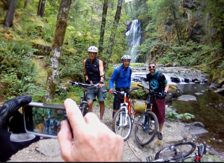
The trail follows Chinook creek for several hundred yard to a falls.
The creek bed is wide and the water flow was low so our crossing was fairly simple, using our bikes to brace ourselves, we worked from rock to rock.
A great photo opportunity presented itself as we stood on the far bank and had the cascading water fall at our backs.
We rode for a short ways along the eastern bank of the Siouxon. The trail had a good solid incline and it was a head down grind, up to the next trail junction.
The Wildcat trail and the Cascade trail made a junction, where the Cascade trail turned away from the Siouxon and started a very strong climb. The ascent averaged around an 18% grade for the next mile with a very steep side hill.
We pushed our bikes, with one hand grasping the stem and the other holding the grip on the handle bar, I leaned into the bike and pushed. Like a little boy standing on his toes to get a kiss from mom, my heals felt like they never touched the ground as we inched our way up the hill.
There were lots of false starts, where we would see the incline diminish, jump up on our bikes and start peddling, to round the next bend and be pulled right back off.
After a good half to three quarters of an hour of pushing, the line finally broke. The tread was rough and rooty. There was a section of trail where I was hammering over dense roots when I heard that awful twang of a spoke breaking. I stopped and pulled the broken spoke out and hoped that I would not hear that sound again today.
The trail wound out of a small valley and around the ridge to follow an old double track.
The track runs across the timber covered hillside. The line taking a small portion of the available track, the rest mostly overgrown with underbrush.
We rode along, finding a fire ring that was most likely left by a hunter or dispersed camper who had accessed the area on the gravel road that we were quickly approaching.
When we reached the gravel, we took a left and headed toward a rocky peak that stuck up out of the timber covered hills.
The gravel road degraded and was soon a meandering single track on a wide plane that was once a road.
As we cranked our way up the grade, a low grade climb that was not quite sustainable in the middle ring, I could see a slide area up ahead that had taken the road with it.
The slide was only about twenty feet wide but extended down the hillside for hundreds of feet. No room for a mistake here! A slip could send you tumbling for a long ways.
There was the trace of a track across the lose dirt. It climbed a few feet before angling down and onto the firm tread on the opposite side.
I picked up my bike and forcing my focus to the lose slough, put my foot down onto the soft dirt. Without ever looking down the slide, leaning toward the hillside, my hand outstretched, lightly touching the ground as I quickly dabbed my way across.
After we had all made the other side, we again started riding up the old double track.
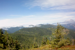
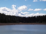
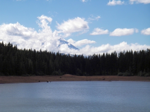
Mt Saint Helens was directly ahead of us as we rode. Mt Rainier sitting off to the east from there.
The trail was rough with lots of lose rock, what would seem to be the base layer for laying down a forest road.
The rock, large water breaks, and a few down trees made the going somewhat rough.
After a short break to take in the grandeur of the major peaks, with the valleys hidden below the low lying clouds, we pressed on.
The double track turned into the timber and the trail continued to climb. The degree of difficulty varied as the track would ascend then traverse to ascend again until the double track came to an abrupt end at a large rock outcropping. I could not tell if it was the outcropping we had seen from down below or another one, but the trail turned hard to the right here and became a single track that was too steep to ride and we were back to pushing our bikes.
We continued to push up the trail and around a couple of more switchbacks.
The deep blue of the sky back lit the timber as the trail rounded a bend and crossed out onto a rock face.
It was one of those scenes that photographers love to catch, the solid rock face curving across your view, the trail carved into the rock with two volcanic peaks off in the distance. Incredibly beautiful in an almost frightening way.
We had reached the top. In front of us was a rocky face with a small flat area and a panoramic view.
The true top of Siouxon Peak was a couple hundred feet further down the trail, a small spur that was not ride-able took us up to the top and another view that exposed the mountains to the south and east.
The peak, a rocky naked peak that stood out above the surrounding forest and afforded a view in all directions. The evidence of a fire lookout in the form of anchors and bits of cable still remained.
We took a short break and ate a bite of lunch before we started the descent.
I'm not sure where the Chinook trail ends and the Huffman trail starts, one runs into or concurrent with the other. But we started our descent from the top of Siouxon Peak.
The trail is a narrow ribbon running across the hillside. The side hill exposure is heavy to extreme right from the start.
The line running fast at a moderate slope, twelve to thirteen percent, as it traverses the hillside, running down from the peak. The hillside presents a side hill exposure that is in the neighborhood of fifty five to sixty percent. So it is an intense fast descent over the next half mile or so.
It only takes a few minutes to blast down through the woods to where the line flows out of the traverse and onto the top of a wide ridge to flatten out and cruise along through large timber.
A few minutes of cruising and the trail breaks off to the left or west side of the ridge; a fast run on a narrow line.
The trail moves back to the top of the ridge and climbs up an easy grade.
The line tracks back and forth over the ridge top, running down the west side, then rolling along the top for a bit and back onto the east side. The tread is good forest loam for the most part with the line traversing some steep slopes when on both the east and west side of the ridge.
The trail crosses a large rock slide at one point, dragging me from my bike to walk it. It is very ride-able but as far out as we are, response to an incident would take hours so I felt it best not to press my luck.
The exposure to the side hill slope also varies from almost nothing to extreme. At one point we were riding on top of a cliff. The line wide enough until the trail presents a large bolder to ride over. In most cases this would be an easy loft and cross but here, the penalty is huge so I opted to dismount and walk the next fifty feet.
The trail continues to follow a flat line around a butte, Huffman Butte I believe, a solid rock wall on one side and an open expanse on the other. A very exciting line that had all of us off our bikes for at least a part of this section.
The trail makes a quick transition from the exposed line to the top of another ridge.
A trail junction with the North Siouxon Trail trail #126 pops up on the top of the ridge. The trail looks impassable, I can see that there are a half dozen trees across the line from the junction.
The trail moves off the top of the ridge to follow the ridge down the west side. Again a narrow line that is traversing a steep hillside exposure.
The line is hard to see at times because of the thick brush through this section. There is some concern in my mind about hidden obstacles, I would not want to make a pedal strike while blasting along this line.
It is still a fast and fun run, even though a bit sketchy. The trail rolling up and down through the bear grass and ferns.
After a mile or so, the line crosses back onto the top of a ridge.
The slope increases on the descent and we start to scream down the hill. It is a very fast section that is steep, approaching a twenty percent grade. I find myself back over the rear wheel, arms outstretched, applying enough break to maintain control but not so much to cause me to start skidding.
The grade eases up a bit and the descent screams as the trail meanders back and forth across the ridge. The line following the west side of the ridge most of the time.
The trail moves close to a sharp drop, the trees all but disappear and the view from the saddle is expansive. Then quickly the expanse fades and the trail roars through small trees before tracking back into the big timber for another steep descent.
In a few moments I come up on Kris. He is picking himself out of the brush, after coming into a corner just a little too hot. The angle of the slope just has you blasting before you know it.
Still grinning, he pushes off and within a couple of seconds he is pulling away and soon out of sight.
We regroup in the forest, the slope almost flat. Bob and Kris are sitting on an old log waiting for Vaughn and I.
The trail provides a line that rips as we take off for the final leg of the descent. The grade is mellow which makes for a very fast run.
It doesn't last long. As we come around a corner, Kris is just a few feet in front of me, skids the back end of his bike around and comes to a stop, yielding to me as the slope drops radically.
I push back over the rear wheel and ease my way into the descent. The trail dropping into a steep turn to start a traverse on a skinny line that angles across the steep hillside. In many places the trail rolls over the arch formed by the trees clinging to the hillside.
The thick undergrowth of ferns and oregon grape shadowing the line and making navigation that much more fragmented.
As I rounded a steep turn, the trees were back lit with bright sun shine where the hillside dropped away to the Siouxon Creek that was just below.
The very steep turn dropped straight down and swung back into another turn to cut a line across the hillside and up to the edge of the creek.
Then a quick turn and drop out of the timber to skid to a stop at the edge of the Siouxon.
The creek is wide, at least twenty to thirty feet. The water was calm and slow moving above us and breaking over rocks to flow through wide rapids below.
Bob was the first to make an attempt at the crossing. He used his bike as a crutch and inched from rock to rock.
Kris and I followed his line and I only dabbed my foot under water in a couple of places. The creek was much deeper than I was expecting and the rocks were very slick, I did have a couple of seconds where I was sure I would be swimming soon.
I think Kris may have hit one of those spots too, since I looked up to see him knee deep in the water as he shuffled his bike across.
Vaughn skidded down the slope and with scarcely a hesitation, picked up his bike and waded straight across.
The climb from Siouxon Creek up to the main trail was a nine hundred foot elevation gain and it felt like we were gaining about a foot up for every foot forward, a straight up hike a bike.
The final mile was all climbing, it is such a great fast run on the way down. Still not too bad for a climb, a low mid to low range gear climb.
The ride had taken us around six and a half hours. We cranked out more then twenty miles with 4,820 feet of climbing.
I would not hesitate to recommend this ride to an advanced rider, I would not recommend it to someone that does not have a lot of experience in the saddle. It would be easy to get in over your head.
On 9/4/2013 4:22 PM, Post Canyon Tom wrote:
In a quandary I am, seeing that I have no back brake and the new tires I recently placed on my bike are cheap-ass untested POS from wal*fart. However, it's
Labor Day weekend and I must achieve something.
Operating, as usual, against all odds as a fool's fool, I decide to nonetheless take advantage of Kook
Scott's ad hoc Labor Day shuttle service from Kingsley Reservoir high up in Post Canyon.
Though I know by heart the mid and lower
sections of the Post Canyon Mountain Bike Park complex, the upper sections remain Terre Incognito, seeing that they require a transfer to reach.
At 9:00 AM on
Sunday, I meet up with Kook Scott at the base of Post Canyon and off we go in his van that tows a trailer on which sits my bike.
In 20 minutes we reach Kingsley
Reservoir; a more uninspiring body of water there is not.
I soon chase off after some fellow mountain bikers and ask if
they are riding over to trail #170, also called "Dirt Surfer." Having replied in the positive, I decide to follow them.
After huffing and puffing up
some crap-ass hill, I come to see that these same bikers have elected to enter Dirt Surfer at its mid-point instead of at its beginning higher up the
mountain.
I announce to them my disappointment at having been lead to bogus point of origin. Yeah, I know, they never asked to be my
guide.
Somewhat perturbed, I head back down the crappy gravel logging road in search of the correct trail that takes one up to the top.
One lucky
guess after another soon has me navigating the dizzying array of skid trails to the beginning of Dirt Surfer.
Okay, finally, it is time for a semi-epic downhill
run that I have dreamed years of accomplishing.
Now the only problems are these funky tires of mine and the lack of a back brake.
Who else do you know would
set off on a day of downhill runs without a back brake?
Oh well, what else can I do? One must live with what you have and right now I have very little. Truth be told, I am
more concerned about the tires than the brakes.
Moments after pushing off I can see that Dirt Surfer will indeed live up to its name.
Nirvana is nearly reached as
I careen over baby head rocks and pick up steam. Gravity does its thing and soon I find myself flying downhill, a monkey man on his funky-ass machine.
Halfway down Dirt Surfer I consult my map and see that I have taken a wrong turn. I decide to correct the mistake by biking back uphill to the last trail junction.
Soon, I am
back on course and the decent continues.
In two hours I reach the bottom and meet up with Kook Scott again. I tell him that I wish for another shuttle ride to the
top.
After a quick bite to eat, I am off once more. For my second run I decide to take an entirely different path down. I study my map intensely and discover a
route that will do just this.
I ride for the first time trails called Super D and Sexy Beast (a new name for Intel Mike?).
I take a bit more time and reach
the bottom in three hours. Exhausted, I can think of just one thing, a cold can of (cheap) beer.
On Monday, the last day that Kook Scott is offering his shuttling
services, I decide to link together the trails down that I consider to be the best.
I also discover that by "pumping the poop" out of my back brake it
kinda comes alive; this is to say that I can now slow myself enough to prevent a full-scale collision with the huge Douglas fir trees that line the trail.
On
balance, I experience two great days of "downhill runs" in Post Canyon. It takes three summers to do so, but I can now say that I have ridden every XC trail
north from Kingsley Reservoir.
If you ever have a hankering for some riding in Post Canyon, I offer my pro bono guide services to you!
Peace-Out,
tomt (Tom Tracey)


