Since we are visiting Tucson for a couple of months, we found a place in south Tucson that was just a couple of miles from the Robles Trail System.
Robles and Star Pass are two systems located on either side of Ajo Highway (pronounced AhhHo) and they are joined by a culvert that passes under the highway.
I have been accessing Robles via the Creosote trail head off Irvington Rd.
The trail is not posted but it is not difficult to locate. Just a few feet from where the pavement ends, a visible track serpentines up through the cactus. If you miss that, there are a couple of jeep roads headed up the hill and the trail crosses them a couple hundred yards up.
This trail, the Creosote Loop trail, traverses the rocky hillside, running out toward the base of a rocky bluff before making it's first switchback.
The climb can be made in the small ring gear and the third sprocket gear, which on my bike is a 26 tooth, a low range climb.
There is only one switchback on this climb that I have not cleared in the half dozen times I've tried. The third switchback is a solid rock outcropping that is slightly elevated with a steep incline.
About half way around the Creosote Loop, which is only about a half mile total, the trail is intersected by the Rocky 13 trail.
The Rocky 13 trail is a little over a half mile in length and takes you over the top of the ridge. On the top of the ridge there is a spur that runs to the top of a rocky bluff but I have not ridden it.
Every time I have reached the top of Rocky 13, I hear this little dog go off just like clockwork, yip, yip, yip as I cross the top of the ridge.
The descent on Rocky 13 has a couple of mildly technical switchbacks, but overall is a quick run to the bottom where it runs into the Camaro Loop.
The options here are to ride Camaro Loop ether clockwise or counter-clockwise. Depending on what you want to tackle next will dictate which direction to go.
There are six trails all feeding into the Camaro Loop.
Clockwise will take you down hill on a double track to where the double track meets a road. The trail is at the end of the road, there is another line down a wash that is about half way to the real line, but I don't know where it or if it merges with the real trail.
About a half mile down through a wash and up the other side, a very mild climb, takes you to the next trail junction, Boulder Bench trail.
If your feeling the need for a real challenge then take this line up through four switchbacks, after the first two, there is a large rocky up that requires a little torque to bounce up and over. Like third or fourth sprocket, I have made it once.
It is followed by a couple more switchbacks and a nice rough-go across the side of the mountain and a fast descent.
Boulder Bench leads you out to a loop called Flight Path, now here is the real challenge. I was off my bike a dozen or more times as the trail presented large boulders and rock-ups that were way to technical for me. There were many times it looked like I could make the first obstacle but could see there was just no way I was going to clear one after another, on a climb.
Flight Path is a little over a mile and took me twenty minutes to do. I rode every bit that was ride-able for me, which many times put me on the bike for twenty feet then off the bike for twenty feet. The real technical challenges were mainly on the west side of the hill.
Back on Camaro Loop, a half mile of moderately flat pump and glide trail takes you to the Ledge Surfer.
The Ledge Surfer trail is an access trail that climbs up and over a low ridge, plenty of good do-able rock steps that form small ledges with a drop off the side at one point of a few feet. The ledges are passed in a couple of minutes and the trail returns to the gritty rocky line that form most of these trails.
The line turns to run downhill through a dozen or so widely spaced switchbacks, heading toward Ajo Hwy where the trail terminates at a four foot concrete culvert that passes under the highway. It is a challenging crossing, stooped over pushing your bike through the culvert, black as a moonless night about half way through. The light at the other end, a square that gets a little larger with each step.
Passing under the highway brings you to the Starr Pass trail system, a system I will explore later.
Back at the Camaro Loop it is a short three tenth of a mile to the next trail head, Sunset Pass.
The Sunset Pass trail has an intersection with the 360 Vista trail just a few feet up the trail from Camaro Loop.
Sunset Pass and 360 Vista converge on both ends so either can be taken or it can be turned into a loop to return to Camaro Loop.
I have ridden both in both directions.
A loop can be made by climbing up the 360 Vista trail and returning by Sunset Pass.
The climb up 360 Vista is a challenging climb but doable. I had to take a couple of shots at some of the chunker stuff but I was able to clear everything on the climb. It is a low gear climb with a few places requiring a little more torque.
The climb up 360 Vista from the west end is a little more challenging. Not a bad climb until the last third of a mile where it becomes very chunky with a switchback that was not possible for me and drug me from my bike to walk the next fifty feet which was probably a hundred feet from the top.
Once the top of the 360 Vista is gained, the descent heading west can be a little tricky. The trail on the top is an old jeep road and the single track cuts off to the right just as the old jeep road starts to break into a steeper descent; easy to miss but the single track crosses the old jeep road a couple more times.
Sunset Pass is very a solid fun line from either direction. From the west it is mostly a descent with lots of little rock drops, which means that from the east they are rock ups. A small bounce and crank will gain the step, with the rest of the line being a mix of fast running gravel with rock and rubble.
After the junction of 360 Vista with Sunset Pass, Sunset Pass continues on toward the north and west. It takes you past the Bittersweet trail junction and eventually takes you to Ajo Hwy through a series of switchbacks that descend to another culvert crossing under the highway.
This culvert under Ajo is a six foot high rectangular concrete tube that you can ride through from one end to the other, the walls decorated with colorful graffiti as you enter, putting you in the Starr Pass trail system on the other side. It is again very dark. As I rode through the tube my eyes did not adjust very quickly and I almost felt blind at one point, staring at the lighted rectangle off in the distance.
Again crossing under Ajo Hwy takes you into the Starr Pass trail system.
Back up the Sunset Pass trail at the junction with the Bittersweet trail.
The Bittersweet junction is a switchback that turns you around and heads you south and eventually east. The first part of the trail swooping and flowing through a grove of palo verde trees, then turning to make an easy climb to another trail junction with the Cascabel trail.
The Cascabel is a loop trail that runs down to a trail access from Irvington Rd then back up to the Bittersweet trail junction.
The Cascabel from the junction with Bittersweet starts with a couple of rock-ups but as soon as the main loop is gained it turns into the fastest trail with real flow in the system. For a desert trail, it is smooth and quick, rolling through a series of small washes for the first half mile until it hits a double track.
I lost the trail here and picked up a rough double track, thinking that was the trail, I climbed up through short technical sections until I reached the single track again and realized I had lost it. Wanting to ride the single track out, I turned around and headed back to where I had hit the double track.
I rode around on double track looking for a sign or trail head, I never did find the trail head and finally spotted the single track running a few feet away as it paralleled the jeep road I was on.
The line again smoothed out and rolled through more small washes and over low profile ridges until I was back at the point where I had turned around on the jeep trail.
The trail passed under a rocky outcropping and in a few hundred yards I was back at the trail head.
Back on the Bittersweet trail, I shifted down and settled into a moderate pace as the trail climbed a little and descended a little to circle around and start traversing the ridge line in a serious climb.
The climb is one that requires torque and forced me into a low-mid range gear so I could clear the features presented by the trail.
I have found that there is one spot on the climb where it is a power step up that is followed by an even steeper step up and I have yet to be able to clear it. Looking at it from the top down it looks like there is a doable line to the uphill side of the trail. It feels like you need to have the power to clear the first step up but need a low range to make the second step, which is very steep.
As the trail approaches the edge of the ridge the climb flattens out for a brief rest. Kind of a false summit because you are only about half way up the climb as you make this break.
The level off leads to a quick but short up and down over some large rocky features then settles into a strong climb up and over one rocky feature after another to gain the top of the ridge another quarter mile away.
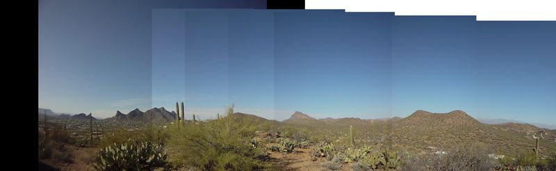
There are great views from all the ridge tops. The hills around here form a classic desert mountain scene where between a couple of mountain peaks, off in the distance, the high rise buildings forming the city of Tucson rise up from the desert floor.
The descent down Bittersweet is the sweet part of the trail. It starts with a short rough rumble over some rocky features to present a quick technical section, then bombs for the next half mile back to the Camaro Loop.
I have ridden Bittersweet trail in both directions now, once from Camaro Loop and as of now, think that is the better direction. The climb is a little more intense, more of a low gear grind but the descent on the south flank of the hill contains more rocky features that I found to be lots of fun going down, more so than climbing up.
Back on Camaro Loop, the trail runs fast for the next half mile to return to Rocky 13 trail.
The climb up Rocky 13 is moderate but mostly doable, with a couple of technical switchbacks to challenge you, then a fun descent back down the Creosote Loop back to the trail head.
The trails as I have laid them out here all source from the Camaro Loop and there is an old rusted out Camaro next to the trail between the Bittersweet trail head and the Sunset trail head hence the name of the trail.
Cat Scratch Fever...the Arizona Trail from Redington Rd to La Milagosa
I got a call from Vern asking if I wanted to do a ride on Sunday... well yes.
We met up at the usual east side meeting place, La Buzz.
There were four of us for the ride, we took off out Tanque Verda Rd which turned into Redington Rd, which climbed up into the hills.
The drive was somewhat intense, at times the road was narrow with very sharp switchbacks. A rough climb that had me switching my truck into four wheel drive to keep the back end from dancing all over.
It took almost forty minutes of a rocky rough ride to get to the trail head.
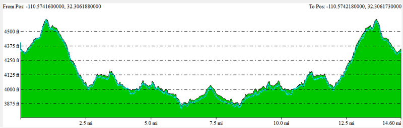
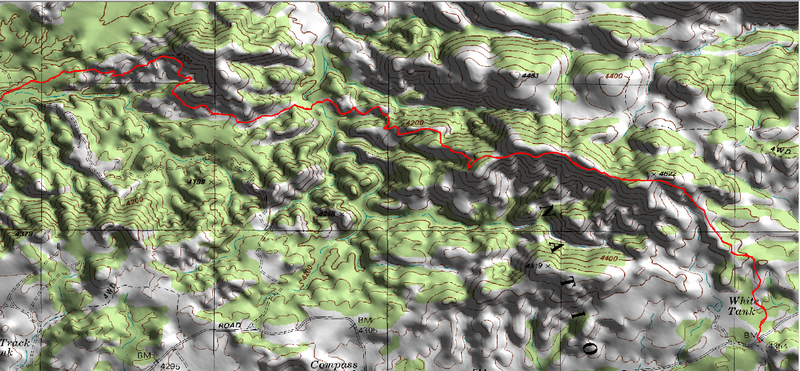
We picked up the Arizona Trail where it crosses the Redington road (GPS 32.306233,-110.574234) and headed off traveling northeast. This section of trail is also know as the Bellota Trail, which is also part of passage #10 which starts 2.8 miles to the south. But the trail head of passage #10 is inaccessible by vehicle. AZT Section #10 Web Page
The trail runs through the grassland with an easy rolling line, a mix of several grass types with cattle grazing across the hillside.
The tread a mix of soil and grit with lots of small rocky outcroppings.
It is a short ride to a moderately steep climb to gain the top of the ridge and the highest point on the ride, around 4800 feet. It had me off my bike at one point where the steep line ascended a set of steps up the side of the hill.
We stopped at the top of the hill for a short break, on the ground was sign from a coyote and next to the scat was more sign but from something else, it was a crumbled pile of reddish orange scat. Vern told me it was Javelina poo.
There was a lot of sign from Javelina and Coyote along the trail.
The trail followed the ridge for a quarter mile or so before dropping off to the western side and beginning a descent that covers about eight hundred feet in a mile and a half.
The trail is well developed with lots and lots of water bar steps that are formed using large six inch pressure treated beams.
A switchback on the top of a ridge steps down over a couple of water bars as it turns back on itself and continues the descent to the next turn in the deep wash that runs steeply down the hillside between the ridges.
The trail flows back and forth from the outer edge of a ridge and back to the bottom of the narrow valley formed by the ridges.
I approached one such turn with the trail again dropping down across a couple of large steps into the little gorge of a valley to present a hard steep up on the opposite side. I moved my weight forward as I lunged up the other side, swinging wide to avoid the water bar on the steep, when I was attacked by a Cat Claw Acacia. Cutting deep into my arm in a couple of places, with one of the claws imbedding itself in my arm.
This was only the first such attack I would suffer this day. The end of the day finding my arms and legs covered in scratches and small dried rivulets of blood.
The descent was fun with lots of gritty single track interspersed with little runs of technical rocky section, ranging from rumbling rock to rocky spines and granite plates.
There were hundreds of water bars in the descent.
As the single track followed the ridge line, the moderately fast descent would have me pushing the bike forward and out as I dropped over the edge of each of the dozen or more water bar beams breaking the line. Every turn into one of the small ravines would present two or three water bar beams to drop across.
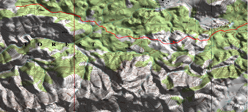
After about four miles, the trail hits a dirt road, the Bellota Ranch Hq Rd, and follows it for a hundred yards before it turns off through an opening in the fence to follow a wash for another hundred yards.
The slope of the line levels off a lot for the next couple of miles and the trail presents lots of fun rocky features to ride. One such place had me off my bike to clear an opening between two large boulders when I noticed a line that ran to the outside, a line that did not look ride-able from the approach but now I could see that it has been built up on either side so you can roll this large boulder.
There are many lines to ride in the rocky stuff and some times the best approach is not to try and weave between the rocks but to roll over them.
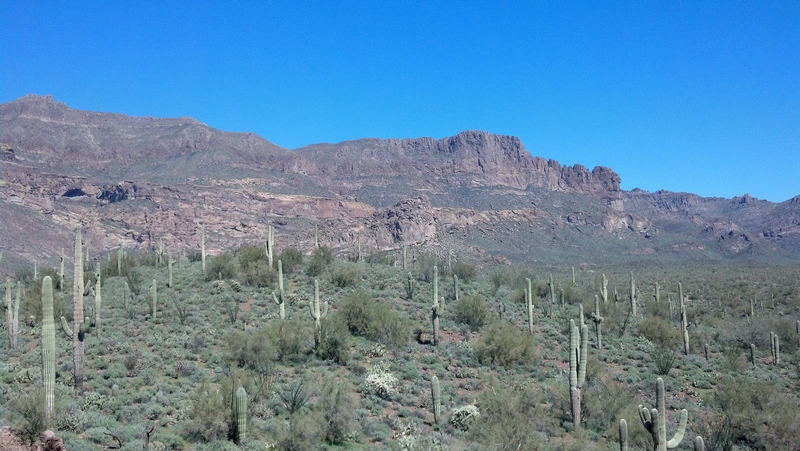
The landscape in this area is more of a high desert, not a lot of cactus but more grass lands and small bushy trees.
Another mile or so and we hit some double track, you would think the ride would be easier on the double track; maybe just a little because there are so many line options. But the features on the climbs and descents were still just as challenging.
We rode at a little quicker pace on the double track and finally hit a wide open area with a grove of naked deciduous trees and evergreen brush standing in the middle of the area. A good sized log laying on the ground, propped up on one end by the exposed roots, with a curved trunk that made for a good lunch log.
After a good break we headed back. We had climbed more on the double track then I had realized, because the return was fast with quick breaking rocky drops that had me back over the wheel with the sound of my breaks lightly modulating as I screamed down the road hopping from one side to the other picking the line.
The ride back across the open grassland was just as fun on the return as it had been on the way out.
A little more of a climb, with rock outcroppings providing challenges. Most of the ride for me was a low gear range, small ring and third or forth sprocket that would give me the torque to maneuver the short steep sections.
The grassy plateaus punctuated on either side with a climb up an exposed granite face, ranging from ten to fifty feet. The key was in negotiating the smoothest rumble across the granite, bursting a short few feet, cranking down with power and just enough speed to make the next break where you can take a few deep breaths for a quick recover, while looking the line over before powering into the next section.
Making the next plateau was rewarded with a fast gritty single track and short little sections of exposed rock, granite plates and rocky steps.
Forty minutes later and we had reached the sandy wash and the dirt road.
A short climb up the road got us back onto the trail, and the first of the water bar beams that would challenge us all the way to the top of the climb. A pair just about twenty feet apart, followed by six more about ten feet apart.
As I approached each step, I would throw my weight back as I pulled up on the handle bars and crank down hard to left the bikes front wheel up onto the steep, then lean forward as the back wheel made contact with the step and crank down hard again.
It had been a fast descent and now we were looking at a grinding climb. The first part was up a ridge line and was a moderate climb with a few little flat or downhill section, as the trail weaved back and forth across the top of the ridge.
Most of the tread here was a solid. It was soil and decomposed granite grit, making for good climbing with little loss of power to a soft track.
The climb increased in intensity after the first ten minutes as the line moved from following the ridge to traversing the hillside. The trail makeup became more mixed rock and rubble with lots of little rock steps, besides the water bar beams.
A couple of the small ravine crossings with a steep ascent from the wash across the water bars had me off my bike and pushing it up the hill for a few feet.
After crossing the flank of a half dozen hillsides, rounding the ridges and heading back into the next ravine, I kept expecting to see the top, to have the goal in sight but it never happened.
It would be another forty minutes of climbing before we reached the top, almost a full hour from where we left the plateaus and the road.
The descent down and back to the head of the trail was a fast rock and rumble ride with a dozen or more step drops to add to the fun.
I noticed on Google maps that this portion of the Arizona Trail is also referred to as the Sky Islands Traverse. The Sky Islands refers to mountain ranges where they are isolated from other mountain ranges by a dramatically different environment.
Millie
Met up with Brian and a few new friends to ride the La Miligrosa on Sunday.
I have ridden this trail three time before. It is a rugged ride on a hard tail.
We started with a shuttle to the Malino camping site where we met up with three other mountain bikers that had ridden up the road.
We started by riding across the Catalina Hwy to pick up the trail.
The trail presents a large stone to pop up over to start, then a little run down to cross a small creek. The trail winds up the steep hillside, ride-able through the first switchback, then it is off the bike for a steep hike.
It is thirty minutes of pushing and at times carrying the bike up the steep trail, taking advantage of the few opportunities to ride if even only a few feet, then back off the bike for more hiking.
Everyone takes a few minutes at the top of the ridge. A place to break and prepare for the trail off the back side of the ridge. Put on some sunscreen and, in my case, some armor.
The line on this side of the ridge is just as rugged as the hike up was, except now we are riding our bikes.
There is a fence running along the top of the ridge and a three foot wide, eight foot long cattle guard. It runs up at a slight angle and back down to drop you on the other side of the fence.
The trail starts with a nice little run on the gritty granite imbedded trail that all to quickly turns down a steep rough descent that pulls me off my bike, as I watch the rider in front of me descend the rocky technical trail. I hear his back wheel skidding through the grit covering the granite slab as I pick up my bike and pick my way down over the next twenty feet to remount and start riding across the steep hillside.
There is a lot of exposure as the ribbon of trail crosses the face of the hillside, forcing my eyes to the trail to focus my mind on each rock and twist of the trail.
The line turns to cross around the face of a rock outcropping. It is a wide line with the outer edge of the trail forming a cliff.
Rounding the outcropping the trail drops steeply through more large granite boulders, again pulling me off my bike to start scrambling, remounting, skidding, scrambling over the next hundred feet of trail as I am off and on my bike several times.
The trail again starts traversing the hillside running fast and almost smooth for a few seconds as I catch up to Brian and the others.
Brian is showing them where the line is, as the trail runs through a rocky slide. He rides up and over a large angular boulder on the edge of the trail, the hillside below the trail strewn with rocks. As I walk my bike through the section, I can't even see how he rode through here but that happens a lot when I ride with Brian.
The trail presents the first of many switchbacks, the hillside falling away from the trail is a little less extreme and I feel a little more comfortable as I remount and ride down through fast gritty single track that is punctuated with half a dozen rocky drops to the next switchback. This switchback again forces me from my bike, a steep set of drops into the turn is more than I can handle.
After each switchback the slope of the hill the trail traverses becomes less and less until the line finally turns to run down the rocky hill.
A very rough line; the trail runs down through the open grassland to cross a low level ridge followed by a short stiff climb that runs up a line of granite with a couple three water bar beams to cross on the climb. The granite tread sprinkled with grit and rubble.
The trail drops off the back of the low ridge, more rough rock drops and rubble, then it turns and descends more as it traverses the ridge until it crosses a small stream at a water tank.
The line widens out a little as the trail climbs for a short ways over more rock and rubble on exposed granite.
The trail turns into a fast double track that we follow for the next half mile. It has a little bit of rumble here and there with a couple of creek crossing to a point where there are a couple of cairns marking the trail junction.
It has taken us about thirty minutes to get here from the top of the ridge.
The single track rumbles through some grass for a few seconds to run into a creek and a favorite spot to stop and test your metal.
It's called the "Water Fall"; a section of trail that makes a ten to twelve foot drop through some steep rock steps.
There are two basic lines through the water fall, maybe that should be three basic lines. One of which is to get off and walk, my line.
There has always been someone ready to take the test, so Brian will show them both lines and give advice along with words of encouragement.
The inside line; the approach is to get a little speed by riding up a granite slab and drop over the edge into a series of rocky steps that drop a foot or more at a time, while making a right turn. The left side of the line is right up against a rock ledge and I have watched more than one rider drop over the first step to balk and lean into the wall. Then go back and try it again and again, some never making it past the first drop.
I think it might have something to do with not being able to see the line until you drop off the first step.
The outside line; similar approach, but higher on the granite slab, a straight line over the edge. No steps just a drop over the edge into a steep roller across a cluster of granite boulders. It is a very narrow line but much smoother then the inside line.
After a great showing of bike handling skills, we make the climb out, a hike a bike for the first fifty feet, up from the creek then some technical climbing to the top of a ridge.
The trail follows the top of the ridge, rolling a good single track with a few rumbling spots, following the natural line of the ridge for a ways, providing moderate climbs and descents.
There is about a mile and a half of trail tracking back and forth across the top of the ridge before starting an increased descending line.
As the trail descends the ridge the technical nature of the line becomes increasingly more demanding.
The trail enters a section that the locals refer to as the rock garden. I have ridden rock gardens in a number of places but never anything this intense. In the four trips down this trail I have never been able to clear this section, and kind of doubt I ever will.
The rock garden section ends with a turn to chunk down a line that runs under a cliff, a section of rock drops along a ledge that form a series of steps to a switchback turn where the ledge continues to finally dump you back out on top of the ridge.
The top of the ridge is a rock and rubble run until it levels off and the single track all of a sudden turns into a smooth gritty line for a very short running approach to the next rocky climb.
It is not a real steep climb but there are a couple of very challenging rock ups, I have to stop a couple of times to gasp for air after dumping all my energy into clearing sections of rocky trail.
The line breaks over the top of the ridge and starts down for a short chunky run to the Spirit tree. A tree with mystical powers if you sit under it and sip on the bottle of Tequila that is located in a rocky niche at the base of the tree. There is a shot glass and a guest register located in an ammo can, also at the base of the tree.
After a sip of liquid courage, which you might need for the next section, a serious descent over the next mile.
The trail returns to the rough and rumble as it follows the top of the ridge to a steep turn which put me back over the wheel as I chunked down over a few granite steps and into a lose rubble ditch to skid a few feet and bounce across more granite to the bottom.
The line runs across the top of a flat ridge, the tread more and more exposed granite in the form of large flat plates with a mix of more rubble.
The plates of granite form steps and ledges to negotiate.
The trail crosses the ridge with plenty of rock drops to descend down the side of the ridge.
The trail provides both sections with options as to how to take on the transition from plate to plate and sections where there are no options, a narrow line squeaking between a rock ledge and a drop-off or a rubble filled rut running between rocks and prickly pear.
The descent gets steep toward the bottom with a couple of places that are very technical with large drops.
This is one of my favorite sections, it is challenging and has me off my bike a half dozen or more times but the stuff that I do feel comfortable with is exciting and rewarding.
I am starting to recognize different sections and looking for different attack angles to sections that defeated me on my last run.
With that said, some times there is a price to be paid. On my last run, although I felt I was doing great I still dropped into a section where I made that oops. I picked a line but didn't follow through and ended up planting my front wheel with me going over the handle bars. I was very thankful for my armor since I landed on my forearm and knee. A couple of scratches above and below my armor and one on my chest. A little shaken, I walked a few feet and remounted my bike to continue the descent.
The bottom of this descent ends in the LaMilagosa creek. A wide area with large smooth granite plates forming the creek bed.
The ledges formed by the plate granite are perfect for sitting in the sun and recovering from the intense racking the previous mile has punished you with.
But the trail does not end here, no not by any means.
The line climbs up out of the creek with a short run combination of hike a bike and riding.
The climb breaks onto a flow of slick rock, wide plates that provides a quick descent down to a gate. I have not found the right line below the gate yet, I keep heading straight down and find myself off the bike to drop over a large ledge.
The trail wraps around the ridge following a line that alternates between plates and gritty rubble to turn down a steep that pulls me from my bike for the next hundred feet. The trail steep, the tread alternates between rock and rubble and granite plate, providing tenuous footing at best. Although the rider in front of me, hopped on her bike after the first twenty feet and skidded down the hill and out of my sight.
The trail runs along the top of the ridge, a technical line that presents a few ups, down, and drops before a short climb to a pack your bike section. I remember last year watching with complete amazement, as Jim Nixon rode this section.
Back on the bike, the trail is again chunky for a few feet then drops again, sharply. Brians words of advice from my first ride ring in my brain, keep to the right side.
The descent is very steep, and starts with a drop in across large rocky steps. A skidding drop that transitions from granite plate to granite plate as it wraps around the ridge to finally drop into a sandy gritty double track.
The trail is double track with one final steep climb up a rocky challenge that requires torque and balance.
A quarter mile of double track and the trail ends on a blacktop road.
24 Hours in Old Pueblo
When I got down to Tucson, Brian asked if I wanted to be on the corporate, 10 man team racing in the 24 hrs. in Old Pueblo. He had registered two teams for the race and was in the process of building teams.
I had told him last year that I would be willing to ride the 24 HOP if I could get on a ten man team.
We headed out to 24 hr town on Thursday to set up our camp.
As we approached the Willow Springs Rd, we could see 24 hr town off in the distance, a good ten miles away.
Brian was already there and had his camp set up.
Thursday night was crisp and cool. We spent a couple of hours around the camp fire. Ann prepared a meal of jambalaya for the four of us that were there.
Friday started the real flow of people coming in and setting up.
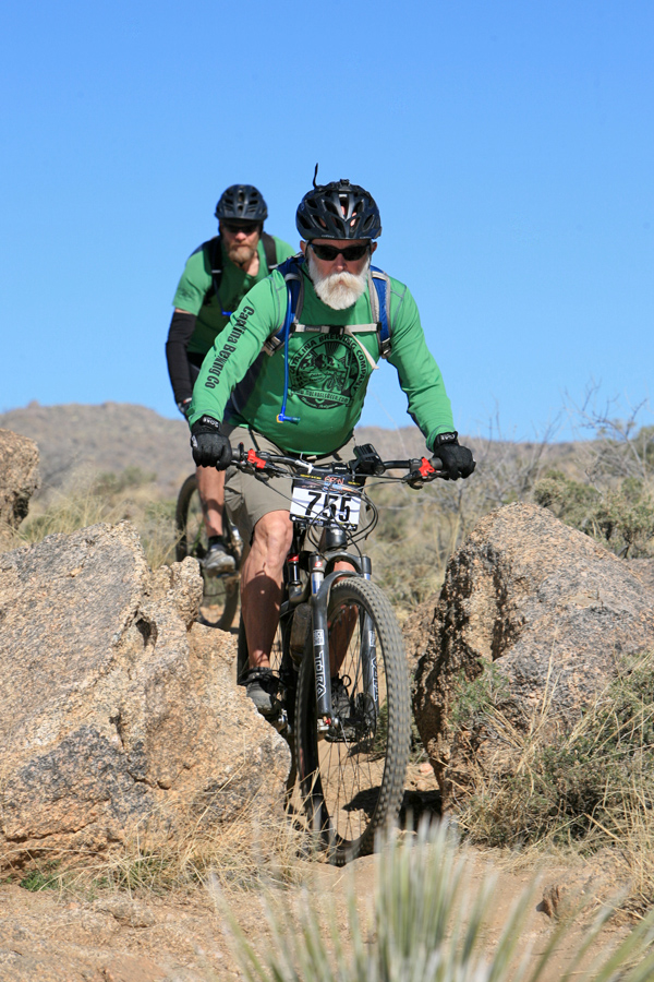
On Friday I helped set up the SDMB (Sonoran Desert Mountain Bicyclists) tent. Later when Hank showed up, I helped him unload the 150+ gallons of beer and set up the taps back at camp. Hank and Brian are the founders of the Catalina Brewing Company, the corporate team I would be riding for.
Friday night was party night, with all the friends and family arriving and setting up camp.
One team, Blue Light Special, all rode the same bike. They all rode the same Target special a Mongoose Bedlam. They wanted to see how many laps it would stand up to. They made ten laps and as far as I know the bike was still working at the end of the race.
One of my Tucson friends was riding solo; Stephen J Jordan made ten laps for a total of one hundred and sixty plus miles. Our camp hosted other friends and riders, there was a team of riders from SoCal (I didn't know any of these riders but did note that one of the guys was wearing a skirt??).
Saturday, the race would start at noon. The first lap riders would run about a half mile to where there bikes were located to start riding.
Our camp was located a couple hundred yards from the starting line.
The Catalina Brewing Co set up a table next to the run and covered it with cups of beer.
The cannon went off and a wave of runners came charging down the hill.
The table and supporters looked like an aid station in a marathon. People holding out red cups of beer for the runners to grab as they ran by. Most just ran on by but there was a surprising number of runners who grabbed that cup of beer and chugged it down as they trotted down the road.
When the wave of runners had passed, all the cups of beer were gone.
It was now a waiting game for me and my first lap in my first race. There were three riders in front of me, I had asked for the forth slot, figuring that would put me with one night lap and one day lap, forth and fourteenth.
The first two riders were seasoned mountain bikers and I could count on a pretty constant time, but the third rider was the wild card, she was an experienced and strong road rider but had only been on a mountain bike for the last month.
The course was a 16.1 mile loop with an option that added another two tenths of a mile. The first three miles or so was down a pipe line road. A straight line with some very steep, rocky descents and ascent. A section of the race route, dubbed "The Bitches", that was notorious for serving up pain. One of the riders on our sister team met with an over the handle bar experience that had her on life flight out of the race, with a broken jaw. She was also a novice to mountain biking but a very strong road rider.
All riders were required to ride "The Bitches" section for the first three hours of the race before the alternate, "Skip The Bitches" was opened up. The "Skip The Bitches" section added two tenths of a mile but was a great section of single track.
The first two riders had each made a lap in just under two hours, putting Penny out for her lap at three forty six.
I waited around camp until about four thirty and then headed down to a location where the trail ran close to 24 hour town. A location called the whiskey tree.
A bottle of Jim Beam and a dozen single shot bottles hung from the tree. There were a dozen or more people all hooten and holleren as the riders came by.
I watched as a female rider came to a stop and grabbed a shot bottle from the tree, threw her head back and poured the contents into her open mouth then with a shout, she remounted and took off down the trail.
I headed up the trail to a vantage point where I could encourage the riders as they came by.
It was about five when Penny came riding up the trail. She looked like the race was testing her but her spirits were high as she smiled at us and rode on down the trail.
I went back to camp to get my stuff together and head for the timing tent.
I arrived at the timing tent just before six. The tent is probably somewhere around forty feet wide by eighty feet long. A row of tables running down ether side where the riders check in and pass the baton to their relief.
There is a constant stream of riders coming into the tent, an announcer is calling out their name and team number as they enter. The relief riders (except for the solo riders) are waiting in one corner of the tent.
I moved into the waiting area and looked for a spot to sit down when I notice my wife had volunteered to check riders through. She motioned me over and told me I can preregister so that all we have to do when Penny shows up is pass the baton.
I waited about forty minutes and as the light was fading outside the announcer called out our team number as Penny entered the tent. She looked like it had been a rough ride.
Taking the baton, I shoved it in my pocket and headed out the exit to get my bike.
With my lights blasting out 1,650 lumens, I took off down the trail.
It had been a year since I had ridden a lap on the course and when I got to the first intersection I took a right to ride the "Skip The Bitches" trail. As I cranked down the twisting turning trail I did not see anyone ahead of me.
The trail meanders a bit before climbing up over a ridge. Still I could not see anyone on my line, either in front or behind me. Off in the distance I could see a dozen lights on the other trail and I started wondering if I had gotten off course.
The trail dropped down the other side of the ridge and crossed a road where there was a guy sitting in an all wheel drive rig, I stopped for a second to ask if I was on the right trail and he assured me this was the bypass trail.
The trail climbed again and put me on a line that ran down the top of the ridge, looking back I could see a couple of sets of lights bouncing and flickering across the hill behind me.
It was dark and the sun had just set. The sky was a pastel red with the hills and a lone rider on the next ridge silhouetted across horizon.
I looked back and could see one of the lights behind me gaining as I was gaining on the lone rider in front of me.
The track was a fast twisting line that moved from ridge to ridge, dipping down through a valley and up on to the next ridge to turn and follow the ridge line until it dropped off the end then turn and cross to the next.
After a few miles of beautiful single track the trail dropped off the end of a ridge and merged with a double track.
I had caught up to the rider in front of me as we entered the double track. The line flattened out and he picked up his pace a little as I dropped in behind him.
It was dark now and the thousand lumen light on my handlebar was pointed straight at the rider in front of me. A small license plate hung off the saddle on his bike, one of those little personalized plates that you can buy at Wallmart or Target, Hans Solo printed on it.
For the next five miles, Hans Solo and I shared the desert night. His little license plate swinging to and fro as we pumped our way through the double track, onto the single track and into the cholla forest.
We hit a drop and a steep climb where his power waned, it was a wide double track, so I leaned into the climb and as I passed Hans I told him that I enjoyed riding with him and wished him luck.
I picked up my pace and thought about strategies that 24 hr racers might employ. The last five miles had been great, just pacing someone with a good cadence had worked well for me on my first leg of my first race.
Alone on the trail, but not. I could see the lights of the racers in front and behind me stretching across the desert.
I was soon passing the now abandoned whiskey tree and heading into a fast section of trail with lots of little dips and turns.
I was gaining on another rider, just in time since I had only ridden this trail once and that had been a year ago.
I pushed myself a little more until I was just a few feet behind him. A good position, I could see as he turned and whipped through the dips and turns.
Maintaining his pace he pulled to the side in a wide spot and I shouted "I'm good" to indicate I didn't need to pass. So again I had found someone with a pace I could maintain.
He was not as willing to share though and after twenty minutes or so he pulled up and I was forced into the pass to crank on until I found someone else to lead me through the dark.
It was more of a technical section of trail so I found myself on another riders wheel in no time at all.
The quick fast paced line ended and a moderate low grade climb started, up to cross the road into 24 hr town and start the final leg.
The climb kind of agreed with me and I found myself passing a half dozen or more riders on this stretch and being passed myself by a half dozen or so riders.
The climb ended with a very rough rumble rocky pass onto the final downhill run back to the timing tent.
At the bottom of the run, the trail passes through camp sites and to a junction with a black diamond line to the left and a blue line to the right, I chose the black diamond since I have ridden it a couple of times before.
The line weaves around through a boulder strewn stretch of trail. A flash from a camera blinded me for a second, just to make negotiating the line a little more exciting. The trail makes a sharp turn and bounces across a couple of small boulder to present a steep twenty feet of skidding down the smooth rock face, bumping across a small gap to skid onto the gritty trail and blast for the timing tent.
Next morning, I checked in with Brian to see when my next lap was.
I was going to be doing the thirteenth lap which turned out to be the last lap for our team.
About an hour before I was going to start my lap, Greg Schuster came by and asked if I would mind if he rode the lap with me. I was delighted to share the experience with Greg.
I got my bike and rode over to Greg's camp at about a quarter after ten; we headed to the timing tent where I spent the next half hour waiting for Melanie Norris.
We made the baton exchange and Greg and I hit the trail.
Two riders took off just before us and I took the lead, setting a pace that was just a little on the high side for me.
We took the "Skip The Bitches" trail. Greg shouted encouragement as we cranked through the turns and climbed up and down over the ridges.
We were about half way through the "Skip The Bitches" section when I came up on Hons, what a surprise. He was moving a bit slower then last night but if he was riding solo, he was doing great.
As I passed him in a wide spot I shouted out a greeting and kept cranking.
When we hit the double track, Greg pulled along side and told me it was really cool watching me from the hill top, he said it looked like I was doing a slalom run, swooping through the curves as I flew down the side of the hill.
He offered to pull me through the desert. He set a pace and I drafted off him, riding as close as I could to his back wheel.
He hit the double track hard, riding into a strong headwind, drafting on Greg was huge here.
We cranked it hard down through the series of dips and twists that make up the middle part of the trail.
The final climb again was a grind, and I think my friend was feeling the effects of doing the middle of the night lap, then helping me with the last lap.
As we approached the saddle that defined the end of the climb, Greg pulled to the side and said "you should take it from here"
I rumbled through the rocky saddle and started blasting down the trail, hitting each dip and hump with all the power I could muster.
The trail headed into a cluster of tents and campsites. There was a group of people on either side of the trail, a couple of strings of flagging material was laid out in the middle of the trail, making an arrow with the head of the arrow a beer can. I pumped the front fork and kicked up and over the can with the crowed cheering as I flew by.
What a great feeling to have all these people cheering as you ride through.
The rock drop section came up fast, the photographer was there snapping pictures and a guy was standing on the top of a jumble of rocks playing a bagpipe, piping us through.
Again I bounced over the lead in and skidded down the rock face to people cheering me on.
A quick dash down the trail to the timing tent to finish the event.
It was a great experience with fantastic weather and friends.
I did my first lap in one hour, thirty six minutes and fifty five seconds and my second lap in one hour, thirty five minutes, and forty nine seconds.
Gold Canyon
Being on the road, there are several possibilities for hooking up with other mountain bikers. The MeetUps websites, local mountain biking groups, a search on the IMBA web site for a group representing them in the local area, and local bike shops.
While here in Tucson I have been using the TucsonMTB web site to check for a group get together and this last week the user agmtb posted a ride for the following Sunday in Gold Canyon.
I responded and met Abe, and Jim at Himmel park where I car pooled with Abe for the two hour drive to Gold Canyon.
We made two more stops and had close to a dozen people headed for Gold Canyon.
Arriving at 9:00 am, the parking lot was large and there were dozens of cars lined up and down the outside of the paved parking area.
We had a good sized group since we also had a contingent from Phoenix join us, and a solo rider, Craig (Craigs Blog) that has spent the last fifty five months riding trails in every state in the continental United States, putting us at near fifteen riders.
We hit the trail that started with a good climb.
The flat gravel path turned to climb immediately, a couple of short rocky steeps that were topped with rock water bars had two riders off their bikes. I was able to bike stand and ratchet my way up and past the two riders to fall in behind another rider, Abe.
After the first switchback the line flatted and smoothed out as it traversed the hillside for a short run to the next switchback, the recover zone.
The climb continued over eight or nine rock water bars that formed short step ups through a moderately steep rocky incline. I was able to maintain a pace that had me breathing hard but not gasping, the torque required to power up the rock steps had me in a low mid-range gear combination.
The riders that tried to spin up the hill were off their bikes in just a few feet, you just have to have the torque or power to bounce up over those steps.
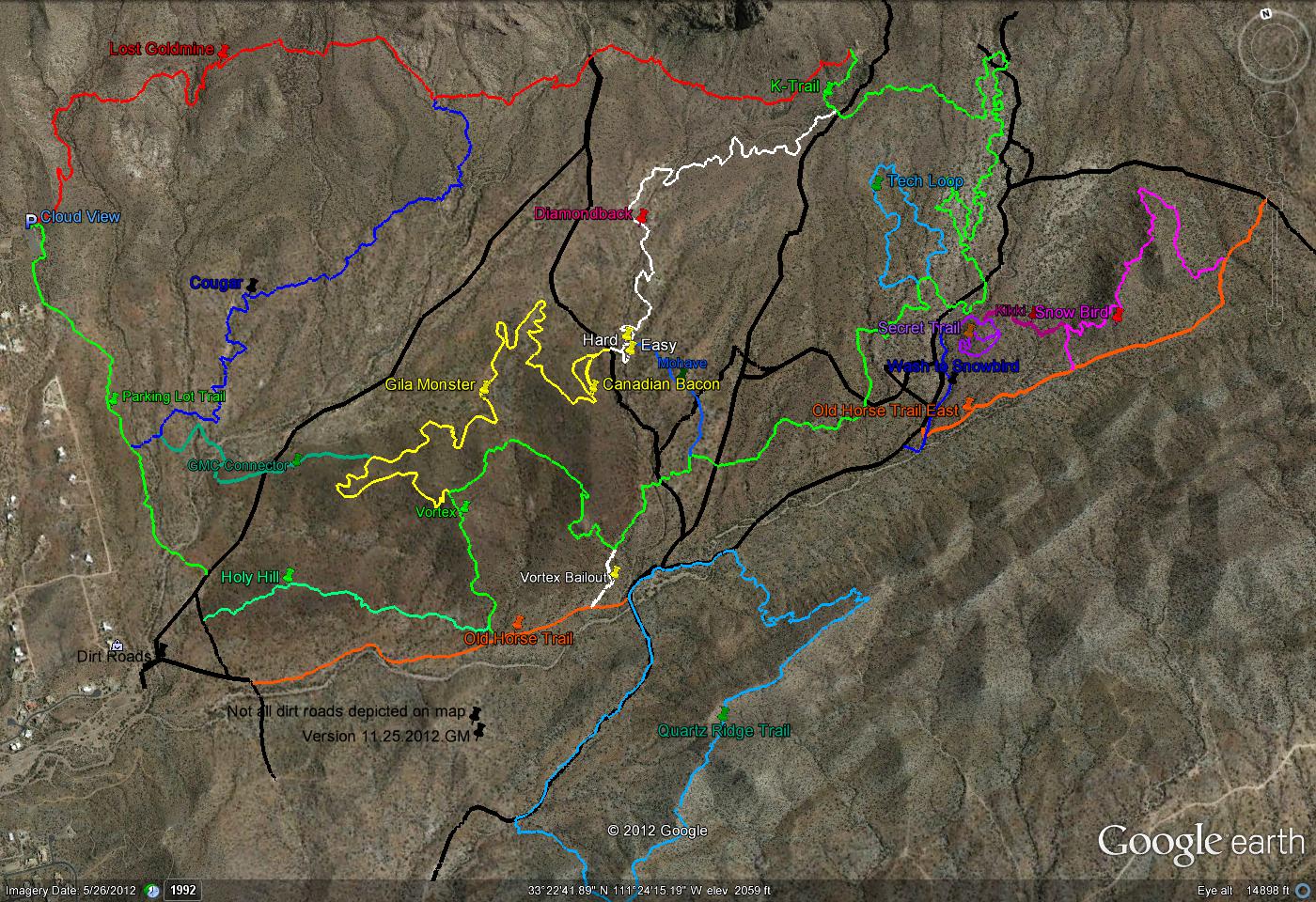
The trail junctions at the top of the climb, a sign indicating petroglyphs were down the left trail, we turned right to follow the Lost Goldmine trail.
The line runs fast through a couple of switchbacks with a little technical when crossing the first wash.
The trail continues with fast rolling terrain until it reaches a short technical climb. I cleared the first turn and climbed to the first switchback. I leaned forward, pressing down hard on the inside pedal to feel the rear tire lose traction. I was drug begrudgingly from my bike to walk the next ten feet.
I waited as two young guys passed me then stuck myself to the last riders back wheel. We climbed up through a couple more switchbacks, negotiating lots of small rocky clusters.
I was finally stopped by some lunkers that were just too large for me, or the guys in front of me, to power up over on the climb. Dropping my seat, I pushed the bike out from under me, up and over the rocks, then slid myself back over the bike. As I leaned forward and started cranking I pressed the button on my handle bar to pop the seat back up under me and finish the climb.
A little more rock and rumble, a couple more short rocky ups to negotiate before the trail turned to descend on a moderate slope for a quick winding run on smooth tread.
The area had seen rain the day before so the tread was almost perfect for this area. A ribbon of dark moist earth ran through the rubble that lined the path.
The next trail junction presented itself at the bottom of the downhill run, the Cougar trail.
There was some discussion about continuing on the Lost Goldmine to the K-trail, we were about half way there or taking the Cougar trail.
Abe felt strongly that the Cougar trail was the better route, we would be making a big loop and would end at the junction of the Lost Goldmine and the K-trail.
The Cougar trail crosses the desert on a fairly smooth line, winding back and forth as it crosses small arroyos.
The group ranged from hammer heads to riders that tried to spin every hill and the Cougar trail accommodated both. The route conformable, with short descents and ascents that lend themselves to a low gear spin. Or you can power this trail, hammering the short descents and blasting up the other side of the arroyo to swoop through the cactus in a mid to high range gear.
Another regroup at the connector trail that linked the Cougar trail with the Gila Monster trail.
It was an easy line that meandered across the desert for a short ways to start a moderate climb that traversed a hill up to the junction with the Gila Monster trail.
The advanced riders arrived and decided to take a chance on trail direction and headed off towards the southeast, when in fact Abe had laid the ride out to take the trail in the opposite direction.
The rest of the group headed up the trail following Abe's guidance to continue the moderate grade climb.
The Gila Monster trail twists and turns with short climbs and descents then a little more climbing before it crests the hilltop. The line starts a fast descent through a big banked corner where you can carry plenty of speed. The corner exits onto a slatted bridge that crosses nothing, not sure why the slatted bridge was there but it is fun. The line runs down over a large granite outcropping, there are a couple of drop options with the main route rolling up and over the rock.
The trail continues to blast down through the desert to cross another wash and up a quick steep.
The line runs fast for another mile or so with more short arroyo crossings and a couple of rocky features to negotiate before reaching the Diamondback trail.
The start of the Diamondback trail gives you two options, the easy line and the hard line, a steep climb up the side of a granite outcropping. The line runs through a wide wash to the bottom of the outcropping, the route outlined up and across the top with the spines from a saguaro cactus.
The Diamondback trail is a low grade climb of about two and a half percent for the next mile or so, an easy fast crank it out in mid range gears while weaving back and forth around the cholla, prickly pear, barrel, and saguaro.
The next intersection is with the K-Trail, a left here takes you to the end of the Lost Goldmine trail, a right takes you down the roller-coaster ride that is the K-Trail.
The line flattens out and hits a few small gullies over the next seven or eight minutes of riding, until it hits the top of a big arroyo where the trail drops quickly through the wash to launch you up the other side. A good place to take advantage of the momentum to stand up and crank up and over the rocky ledge that forms the top of the arroyo.
The line turns to flow back and forth through an arroyo. Starting with a big drop down a gritty hard surface, the right side has a little kicker that some of the riders took advantage of to hit it, scream across and up the other side then turn around and return to repeat until one of the guys took the left line and shot down the trail.
The trail drops in and out of the washes more than two dozen times. The tread a sandy gritty line that bounces across small rocky outcroppings presenting fun features that enhance a great run.
The end of the arroyo run ends with a split that offers two lines, the left has a small slatted bridge crossing a small gorge and the other is a ride around.
A couple minutes more down the K-Trail brings you to the mini-moab feature. A large rocky outcropping that presents an opportunity for skills development.
The K-Trail continues on through another half dozen arroyo crossings. A couple of arroyo crossing drop-ins present a ledge to kick off, rip down and hammer up the other side.
A few minutes further down the line and there is a junction with the technical loop, this can be bypassed if your not up for a little rocky techy stuff.
The technical loop presents alternate lines for each of the features along the loop. The lines are marked with a small white dashes painted on the rocks, in many cases the techy line is the only line marked since the ride around is obvious.
The first and second features do not offer a ride around. The first challenge was a narrow rock channel that climbed just a few feet and offered two drop-outs, the first a little more technical than the second but both looked to be do-able, I took the second. This was followed by a rocky jumble that just requires the rider to shift their weight back and roll it.
Other than a couple of rock rolls, all the remaining features were choice driven, do it or ride around.
The next couple of miles is a fast flowing desert ride. There are a couple of trail junctions with the Mohave and Vortex trails. We turned to ride uphill on the Vortex trail.
The huge rock outcropping, The Vortex, rises up from the desert floor. It is a short but stiff climb approaching six to seven percent grade in a few places. A good place to stop and take in the view, the Superstition Mountains dominating the horizon to the north.
The line runs up and down over the top of a couple of peaks, presenting lots of switchbacks with fast descents and short power climbs over the next mile and a half, finally descending back to the desert floor.
One trail junction on the descent, the Gila Monster trail, then back on it to return on the connector trail.
We turned left at the end of the connector trail instead of riding back up the Cougar trail and took the aptly named Parking Lot Trail.
The final climb was a low intensity climb. A neighborhood overtakes the desert and the trail turns to run parallel to it. Following a barbed wire fence back to the parking lot.
The Gold Canyon trail system has a little of everything you would expect from a desert trail system, smooth fast lines, short fast rock and rumble sections, and nice rocky features. A very fun trail system.

 When I got down to Tucson, Brian asked if I wanted to be on the corporate, 10 man team racing in the 24 hrs. in Old Pueblo. He had registered two teams for the race and was in the process of building teams.
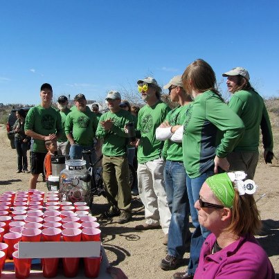